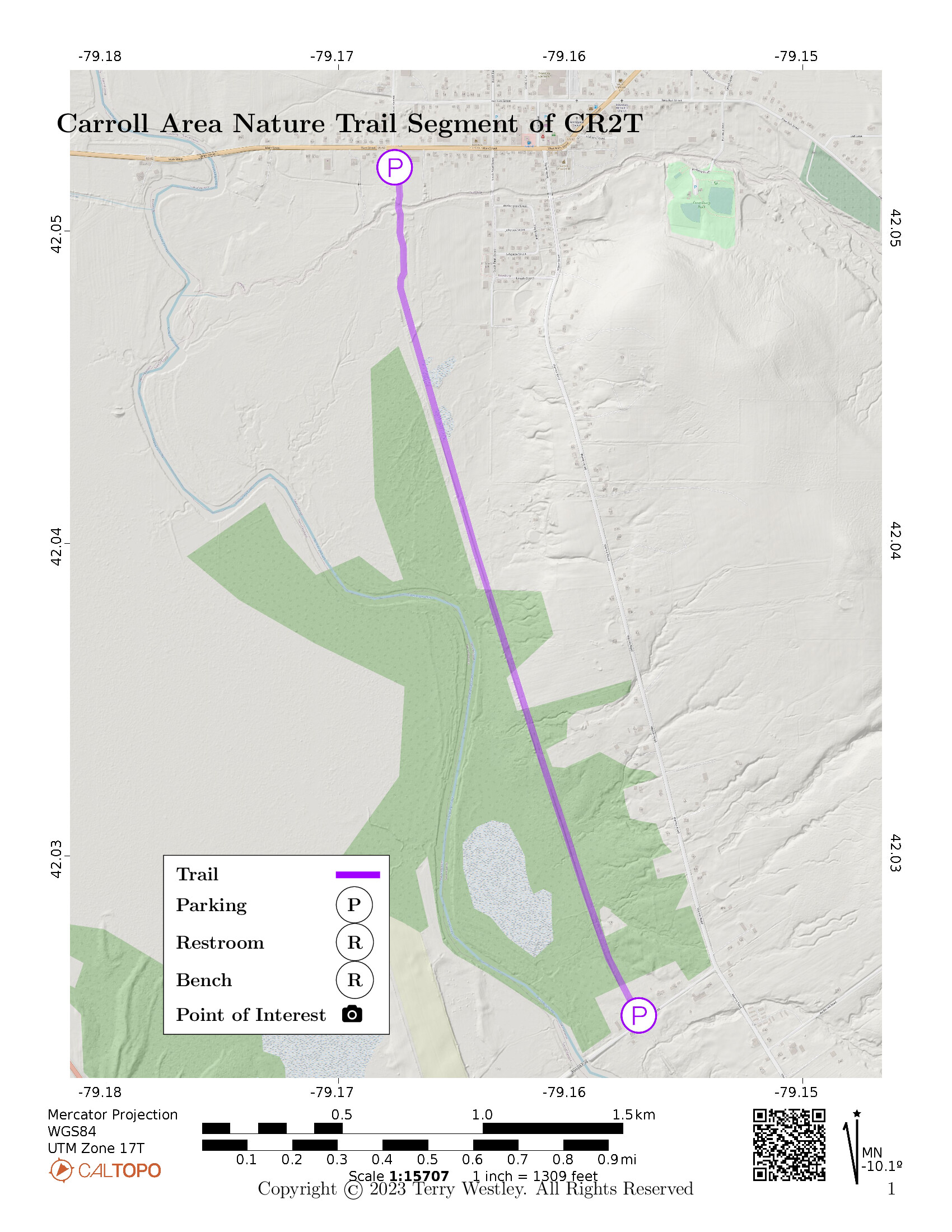
The Carroll Area Nature Trail of the Chautauqua Rails To Trails (CR2T)![]() is a two mile rail trail near Frewsburg, NY.
The northern trailhead in Frewsburg is behind Lobb’s Auto Service.
The southern trailhead is on Riverside Road.
The total elevation gain is 46 feet.
is a two mile rail trail near Frewsburg, NY.
The northern trailhead in Frewsburg is behind Lobb’s Auto Service.
The southern trailhead is on Riverside Road.
The total elevation gain is 46 feet.
| Evidences This is a Rail Trail | |
|---|---|
| For | Against |
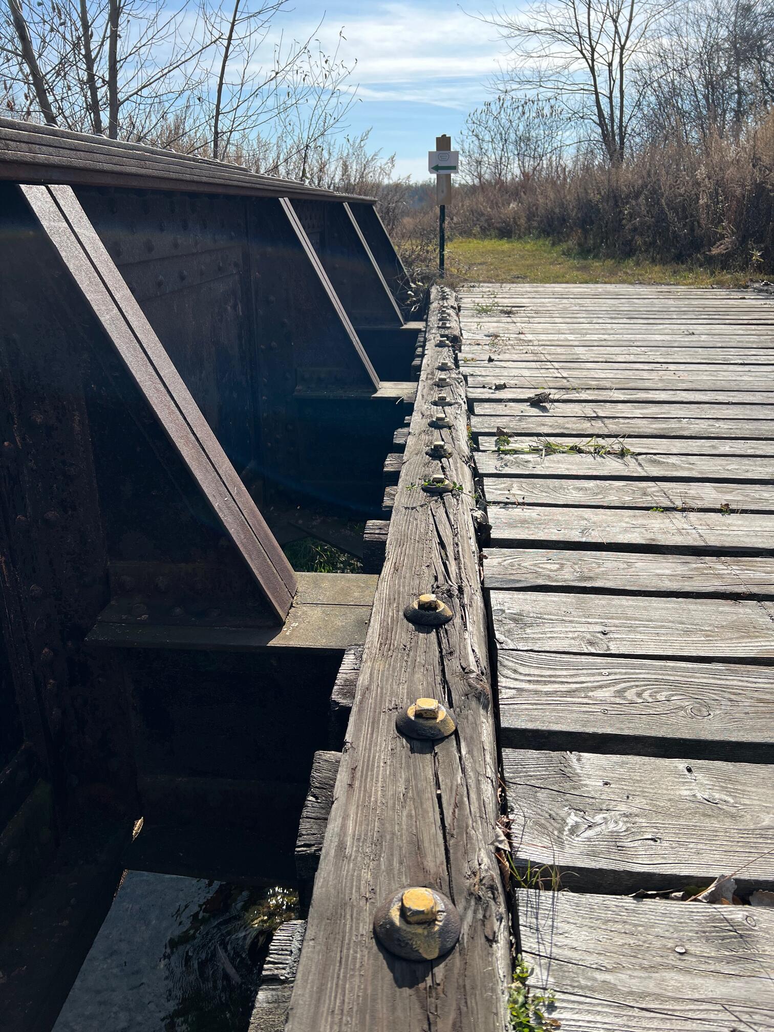
| 19th century railroad bridge | Sharp curves near start of trail |
| Lots of railroad ties in and beside the trail | Many small hills and valleys on the trail |
| Railbed is built up through valleys | Several swampy areas and standing water on the trail |
Conclusion: it’s a rail trail.

Leave No Trace, Ten Essentials
While you’re enjoying the outdoors, please leave no trace![]() to minimize your impact and preserve these special places for others to use as well. If you’re walking or hiking, please pack the REI ten essentials
to minimize your impact and preserve these special places for others to use as well. If you’re walking or hiking, please pack the REI ten essentials![]() for your own safety. When cycling, consider using this REI checklist
for your own safety. When cycling, consider using this REI checklist![]() . For other activities, review the hiking and biking essentials and use your judgement.
. For other activities, review the hiking and biking essentials and use your judgement.
Parking
There is trail designated parking behind Lobb’s Auto Service (129 W Main St). You have to go through the gate in the high fence back to where the trailhead marker is. You can also park along Riverside Road but not on the trail itself there because it is shared with private property.
Trail Surface
The trail surface includes grass, gravel, ballast, and railroad ties. Even without a recent rain, there may be standing water in places.
Please consider carefully whether this trail surface is adequate for your activity.
Restrooms
There are no public restrooms at the trailheads or along the trail.
Points of Interest
Points of interest include:
- 19th century railroad bridge
- Railroad ties embedded in the trail
- Wetlands and woodlands along the trail
- Several side trails. Please don’t explore as these aren’t part of CR2T and are posted against trespassing.
- Lots of small hills and valleys you don’t expect on a rail trail
- The only bench is the very nice one at the Main Street trailhead.
History
From New Rails To Trails Being Planned in Carroll, November 30, 2021 by WRFA Radioleave![]() :
:
A new rails-to-trails is being planned in the town of Carroll. The Chautauqua County Rails to Trails applied for a permit from the State Department of Environmental Conservation for the 2-mile trail that will run from West Main Street in the village of Frewsburg to Riverside Road in the town of Carroll.
Chautauqua Rails to Trail President Emeritus Jim Fincher said they own the former railbed from Frewsburg to Ackley, Pennsylvania and had started working on developing part of the trail.
He said the property on the north end of the trail owned by the Lobb family had been flooded by beavers building dams, “There’s at least five dams in there now and because it was wet, it became wetland. You’ve got the kind of soil, you’ve got the kind of plants, the kind of animals that define it as a wetland. To do much with a wetland, you’ve got to get a permit which is what we did.”
Fincher said the trail will be 10 feet wide and covered with gravel. He estimates that the trail will be open for use by this summer. For the full interview with Jim Fincher and current Chautauqua County Rails to Trails President Bill Ward, tune into Community Matters this Thursday at 5pm here on WRFA.
Hiking Solo (and Running, etc.)
Solo hikers who find themselves able to do the whole point-to-point trail distance but not the out and back may consider using Uber or Lyft to get a ride from where they parked to the other trailhead. Since this trail is in a less populated area, you may have to wait 15 minutes or more for a ride or you may not get a ride at all. I’ve done this several times because I usually hike solo.
Trail Summary
| Distance | 2 miles point to point | 4 miles out and back |
| Elevation gain | 46 feet | |
| Trail surface | Grass, gravel, ballast, and railroad ties | |
| Difficulty | Easy | |
| Lobb’s Auto Service Parking | 42.05205, -79.16757 |
5-10 cars, not paved |
| Riverside Road Parking | 42.02491, -79.15706 |
Side of the road |
Avenza Map
Avenza Map
- Load the PDF map into Avenza app on your smartphone in one of these ways:
- From your smartphone’s browser, tap this link to load the map directly into Avenza.
- From Avenza app’s Import Maps function, scan this QR code.

- Be sure to do this when you have good internet connection. Don’t wait until you are at the trailhead!
For more information about trail maps, see the Maps page.