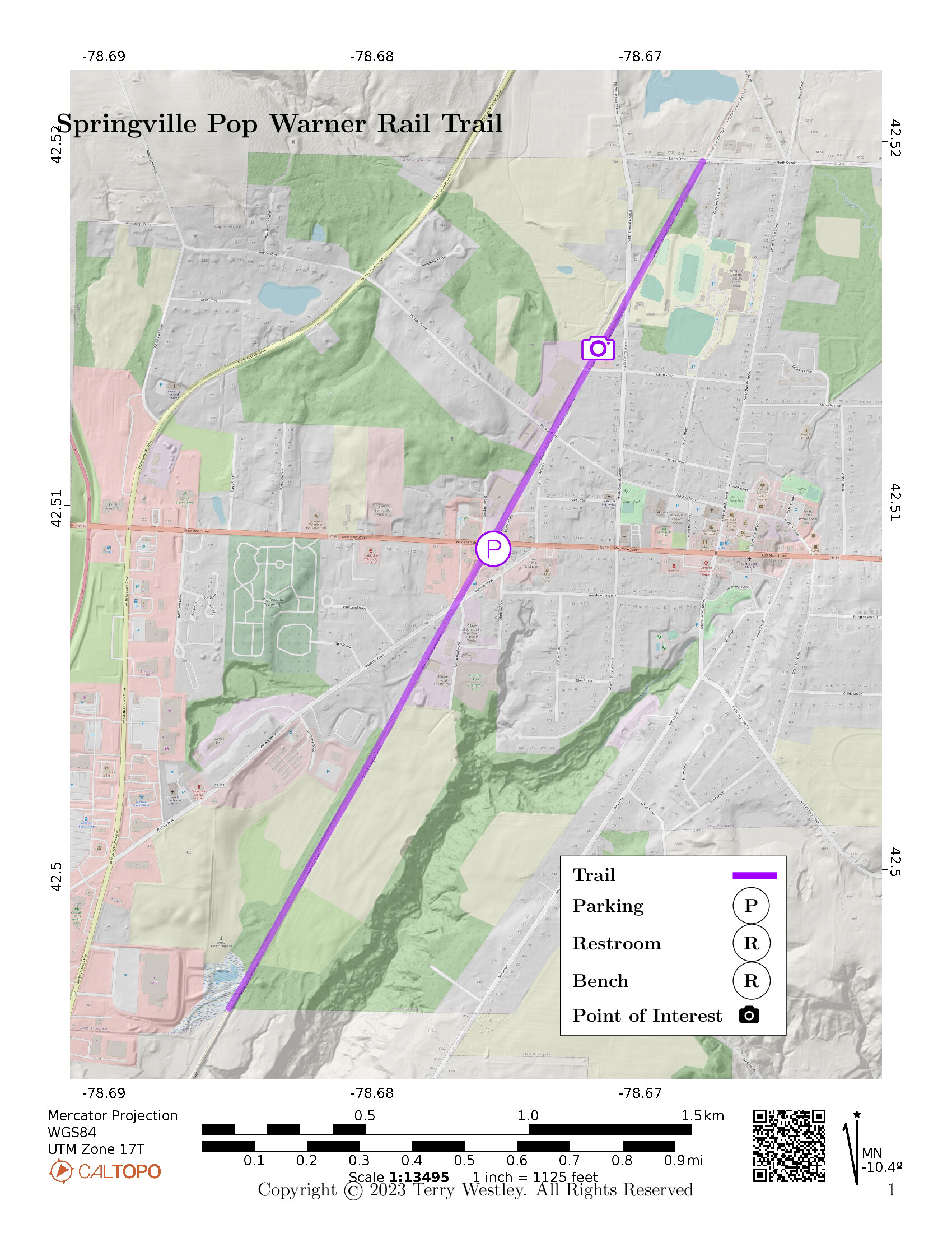
The Springville Pop Warner Trail is 1.8 miles point to point with an elevation gain of 4 feet. Starting at the parking lot on West Main St, if you walk out and back to North Street and then out and back to (behind) Lowe’s, that will be 3.6 miles. You may want to do more or less than that since the trail is pretty good beyond the official boundaries of Pop Warner.
This trail was one of the first sections of the
Erie Cattaraugus Rail Trail, Inc.![]() to open.
More sections have opened since, both north and south of the Pop Warner Trail.
The northern and southern trailheads of this trail are at the northern and southern boundaries respectively of the Village of Springville.
to open.
More sections have opened since, both north and south of the Pop Warner Trail.
The northern and southern trailheads of this trail are at the northern and southern boundaries respectively of the Village of Springville.
Leave No Trace, Ten Essentials
While you’re enjoying the outdoors, please leave no trace![]() to minimize your impact and preserve these special places for others to use as well. If you’re walking or hiking, please pack the REI ten essentials
to minimize your impact and preserve these special places for others to use as well. If you’re walking or hiking, please pack the REI ten essentials![]() for your own safety. When cycling, consider using this REI checklist
for your own safety. When cycling, consider using this REI checklist![]() . For other activities, review the hiking and biking essentials and use your judgement.
. For other activities, review the hiking and biking essentials and use your judgement.
Trail Surface
The trail surface is mostly gravel with some dirt and grass. There are several street intersections.
Please consider carefully whether this trail surface is adequate for your activity.
Restrooms
There are no public restrooms at the trailheads or along the trail. There are restooms in several nearby restaurants.
Points of Interest
A fun point of interest is a beautifully painted mural on a fence north of West Main Street.
History
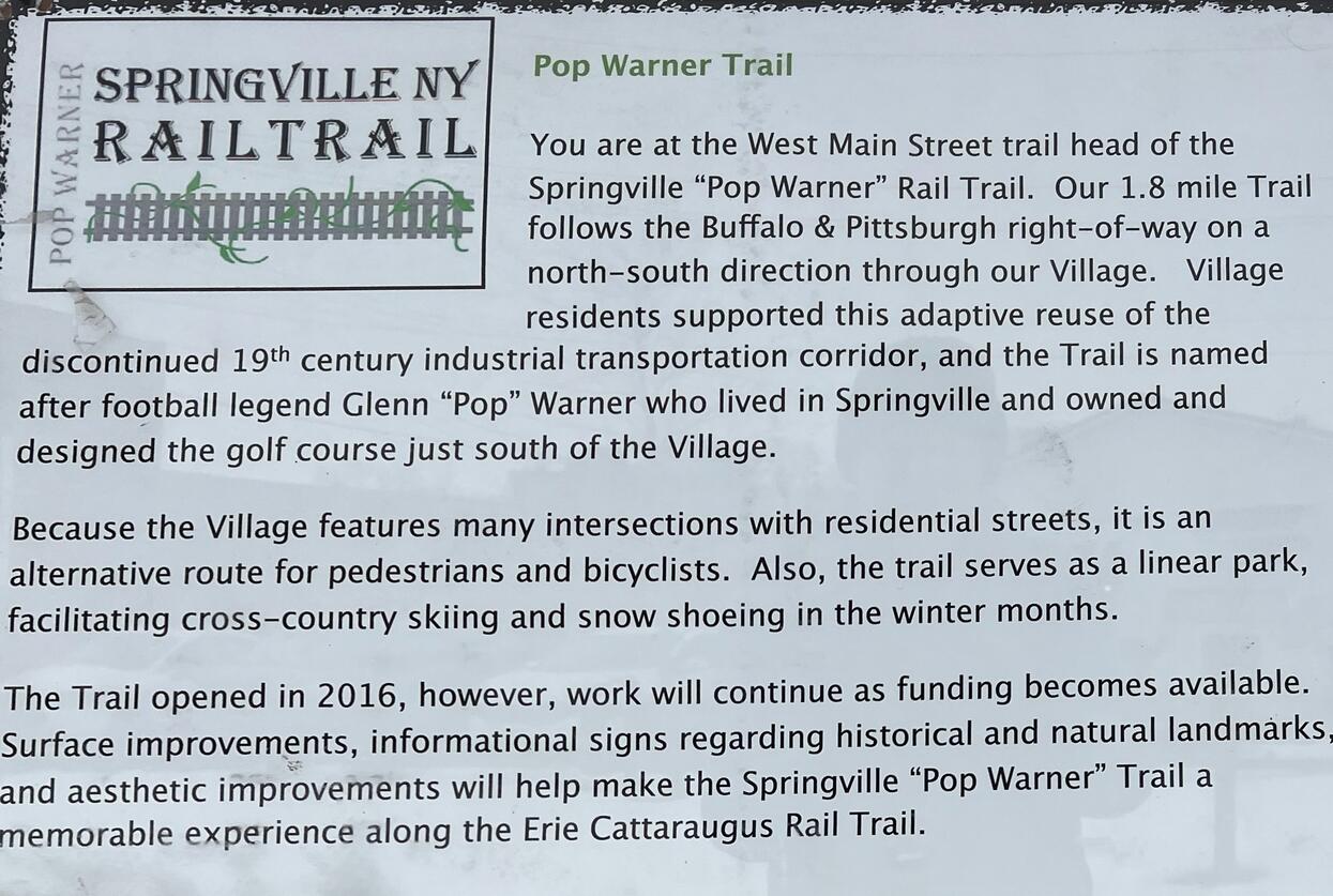
From a sign at the trail head:
Pop Warner Trail
You are at the West Main Street trail head of the Springville Rail Trail. Our 1.8 mile Trail follows the Buffalo & Pittsburgh right-of-way on a north-south direction through our Village. Village residents supported this adaptive reuse of the discontinued 19th century industrial transportation corridor, and the Trail is named after football legend Glenn Warner who lived in Springville and owned and designed the golf course just south of the Village.
Because the Village features many intersections with residential streets, it is an alternative route for pedestrians and bicyclists. Also, the trail serves as a linear park, facilitating cross-country skiing and snow shoeing in the winter months.
The Trail opened in 2016, however, work will continue as funding becomes available. Surface improvements, informational signs regarding historical and natural landmarks, and aesthetic improvements will help make the Springville Trail a memorable experience along the Erie Cattaraugus Rail Trail.
History of Rail Road Corridor
The return of the B&P right-of-way in Springville to a multiuse trail for recreation is a return of the right-of-way to tourist commerce in the railroad’s heyday.
The Buffalo, Rochester, and Pittsburg Railway provided rail service through Springville to haul coal from Pennsylvania to Buffalo and Rochester in the 1880’s. The first passenger service to Springville was on November 19, 1883. The railroad promoted excursions to the Southern Tier, and the scenic Cattaraugus Creek gorge. In 1899 the railroad added the Pavilion on the north bank of the Cattaraugus Creek at the BR&P Bridge, and the popular attraction was known as Cascade Park.
Rail passenger service to Springville ended in 1955. Rail service ended in 1996.
Trail Summary
| Distance | 1.8 miles point to point | 3.6 miles out and back |
| Elevation gain | 4 feet | |
| Trail surface | Gravel, dirt, and grass | |
| Difficulty | Easy | |
| Point of Interest | 42.514325, -78.671806 |
Fence mural |
| Main Street Parking | 42.508853, -78.675391 |
About 20 spaces, not paved, not striped |
Avenza Map
Avenza Map
- Load the PDF map into Avenza app on your smartphone in one of these ways:
- From your smartphone’s browser, tap this link to load the map directly into Avenza.
- From Avenza app’s Import Maps function, scan this QR code.

- Be sure to do this when you have good internet connection. Don’t wait until you are at the trailhead!
For more information about trail maps, see the Maps page.