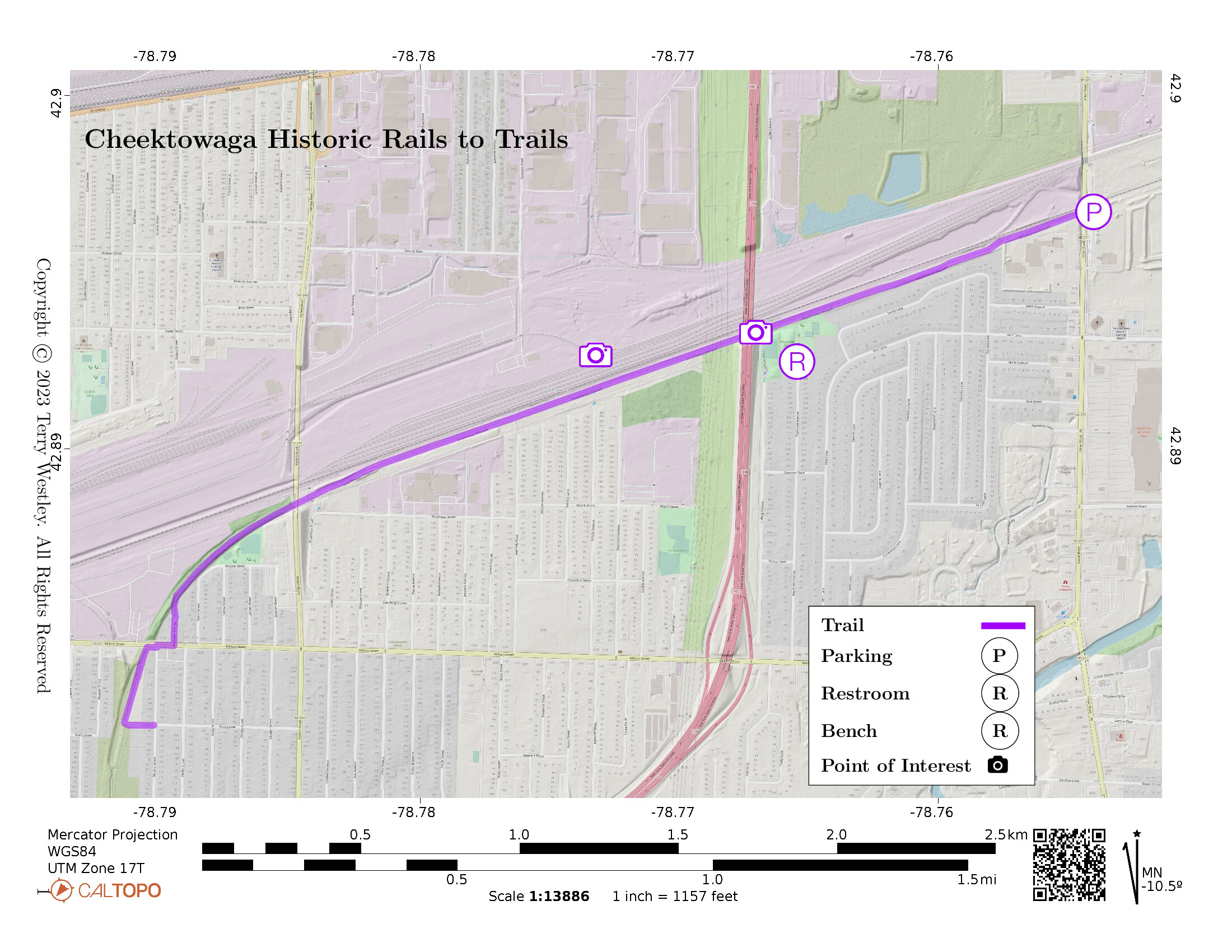
The Cheektowaga Historic Rails to Trails (AKA Lehigh Valley Railroad Rail Trail) is a 2.35 mile, 8-foot wide asphalt trail built on a Lehigh Valley Railroad bed adjacent to an active rail yard. The trail proceeds west and south from Union Road ending at the corner of Hurd and Medina Streets. The trail head has a small parking lot off Union Rd just north of Como Park Boulevard. You can also park at Raymond Park at the north end of Ludwig or Raymond Avenues.
Leave No Trace, Ten Essentials
While you’re enjoying the outdoors, please leave no trace![]() to minimize your impact and preserve these special places for others to use as well. If you’re walking or hiking, please pack the REI ten essentials
to minimize your impact and preserve these special places for others to use as well. If you’re walking or hiking, please pack the REI ten essentials![]() for your own safety. When cycling, consider using this REI checklist
for your own safety. When cycling, consider using this REI checklist![]() . For other activities, review the hiking and biking essentials and use your judgement.
. For other activities, review the hiking and biking essentials and use your judgement.
Trail Surface
The trail is completely paved from end to end. Both the Union Rd and the Raymond Park parking lots are at the same grade level as the trail.
Please consider carefully whether this trail surface is adequate for your activity.
Restrooms
There are public restrooms at Raymond Park.
Points of Interest
If you wait awhile near the train yard, you are likely to see a train engine connecting up with its cars and pulling them.
I-90 and Harlem Road are overpasses above the trail. Union Road goes under a bridge on the trail.
History
A sign at the trail head![]() says:
says:
The area of Cheektowaga known as Forks, New York is located in the middle of the town at the junction of Broadway & Union Roads. A major railroad station was at this location and in the 1920s the present Town Hall was built.
Behind the now existing Town Hall and Highway Garage there are three giant concrete columns. This is all that remain of one of the largest coal trestles ever built in the United States, extending over half a mile.
In the early 1880s most homes and industries were heated with coal as well as ran industries, mills and steam engines. The trestle was built of wood and concrete for the purpose of providing uninterrupted coal service for its customers. It would transfer coal from rail car to waiting horse drawn wagons and later motor driven trucks. Hopper cars would be pushed by a switch engine up the trestle to the second story and the bottom of the hopper would empty their contents into the wagons below.
The coal trestle survived into the 1920s when a fire and its outdated construction would spell its demise.
This is a taste of Lehigh Valley Railroad history from Lehigh Valley Railroad Historical Society![]() :
:
Originally chartered in 1846 to be a transporter of anthracite coal from the vast coal fields of Pennsylvania, the Lehigh Valley Railroad grew into a major carrier of both freight and passengers between Jersey City, New Jersey, and Buffalo, New York.
Hiking Solo (and Running, etc.)
Solo hikers who find themselves able to do the whole point-to-point trail distance but not the out and back may consider using Uber or Lyft to get a ride from where they parked to the other trailhead. Then you can walk to your car from there. Since this trail is in a populated area, you won’t have long to wait for a ride. I’ve done this several times (on other trails) because I usually hike solo.
Trail Summary
| Distance | 2.35 miles | 4.7 miles out and back |
| Elevation gain | 66 feet | |
| Trail surface | Asphalt | |
| Difficulty | Easy | |
| Point of Interest | 42.89331, -78.76703 |
I-90 Overpass |
| Point of Interest | 42.89266, -78.77322 |
Active train yard |
| Union Road parking | 42.896709, -78.75403 |
6 spaces, no handicap |
Avenza Map
Avenza Map
- Load the PDF map into Avenza app on your smartphone in one of these ways:
- From your smartphone’s browser, tap this link to load the map directly into Avenza.
- From Avenza app’s Import Maps function, scan this QR code.

- Be sure to do this when you have good internet connection. Don’t wait until you are at the trailhead!
For more information about trail maps, see the Maps page.