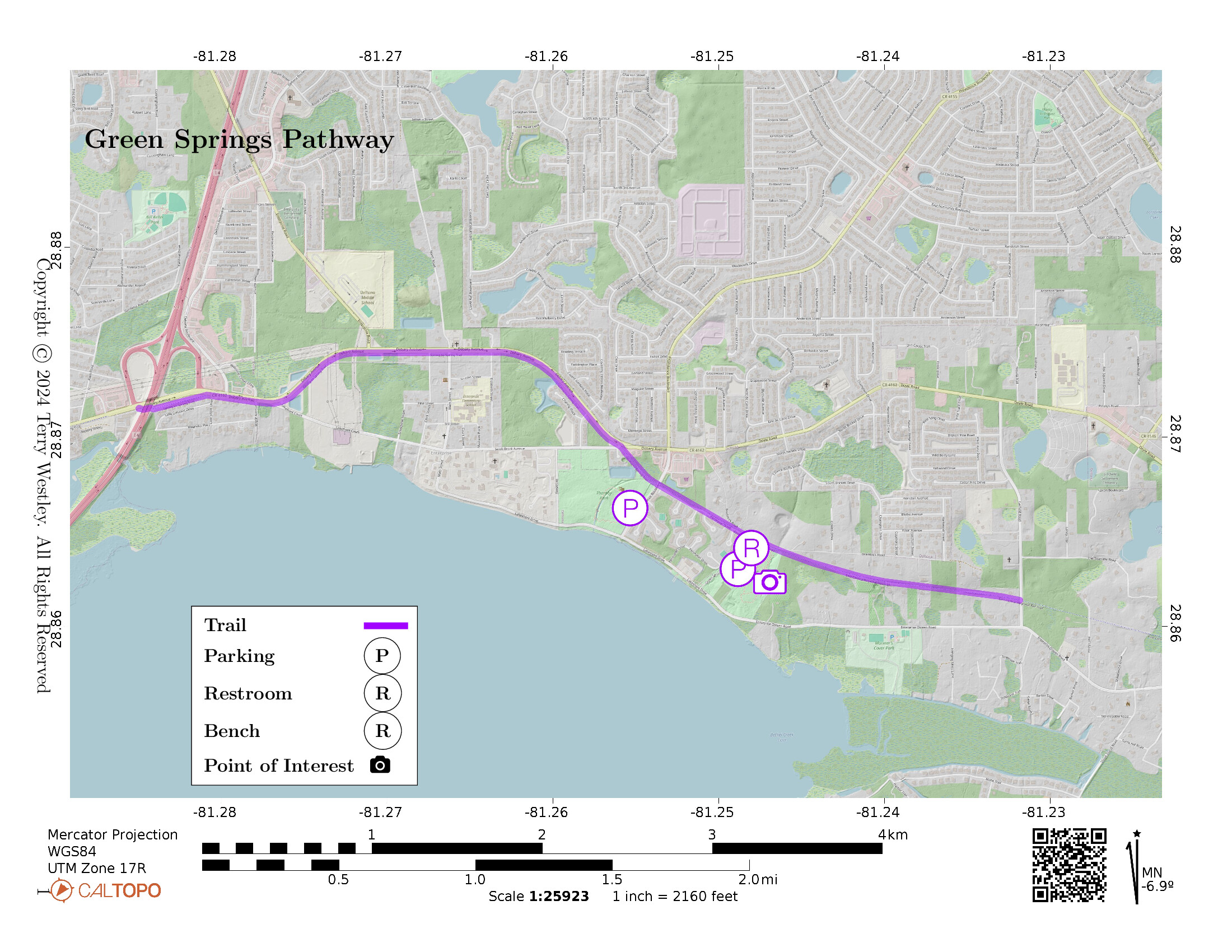
Green Springs Pathway, a portion of East Central Regional Rail Trail![]() , is a 3.57 mile 100% asphalt rail trail in Enterprise, FL.
It proceeds from the I-4 overpass over Debary Ave, through Thornby and Green Springs Parks, and then on to Garfield Road.
East Central Regional Rail Trail is longer than 50 miles and is built on former railbeds of the Florida East Coast Railway
, is a 3.57 mile 100% asphalt rail trail in Enterprise, FL.
It proceeds from the I-4 overpass over Debary Ave, through Thornby and Green Springs Parks, and then on to Garfield Road.
East Central Regional Rail Trail is longer than 50 miles and is built on former railbeds of the Florida East Coast Railway![]() , It is, in turn, part of the St. Johns River-to-Sea Loop
, It is, in turn, part of the St. Johns River-to-Sea Loop![]() multi-use trail system.
The total elevation gain for Green Springs Pathway is 119 feet.
multi-use trail system.
The total elevation gain for Green Springs Pathway is 119 feet.
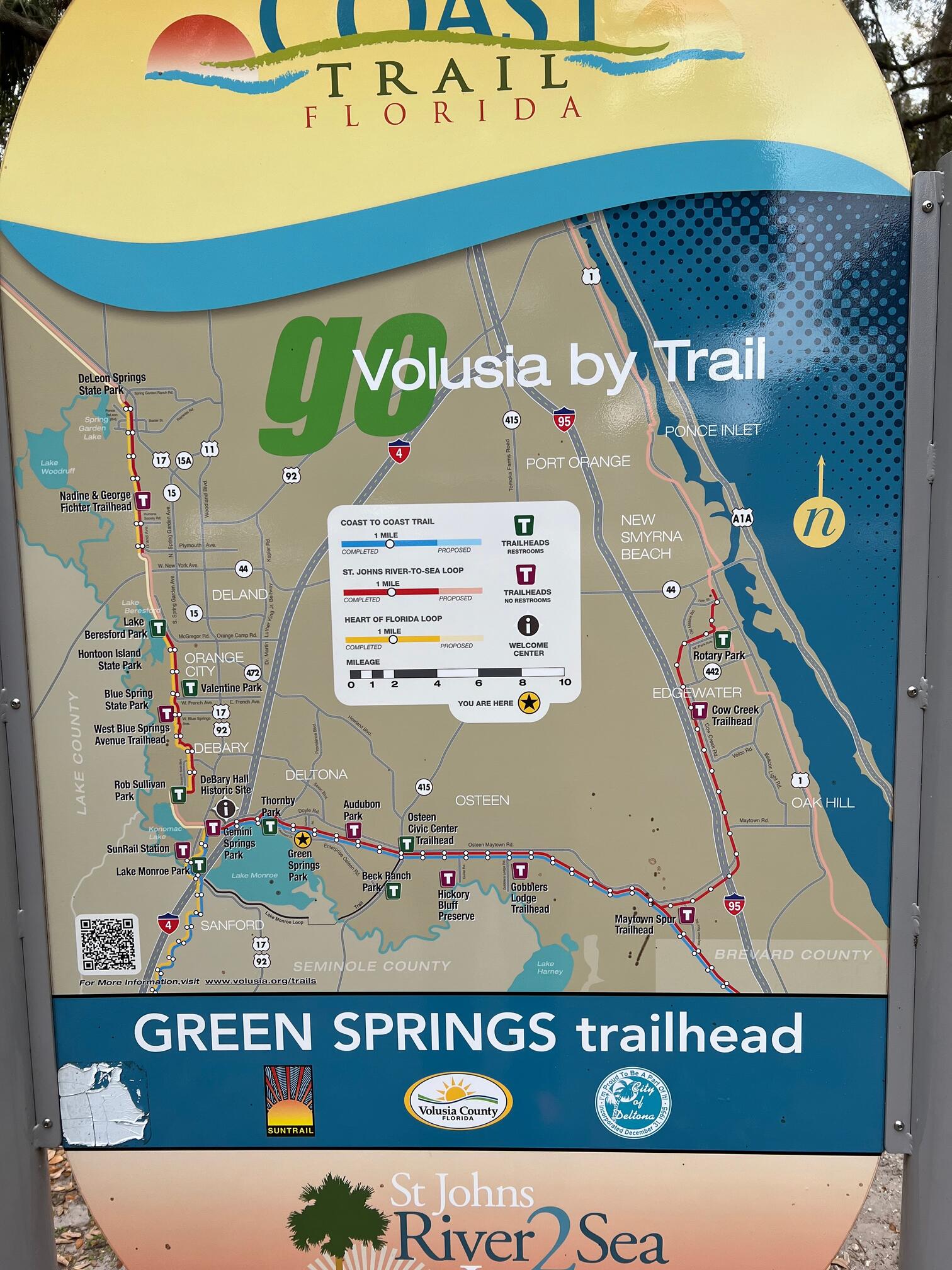
As seen in this Volusia by Trail map, there are trailheads for East Central Regional Rail Trail at
- Audubon Park,
- Beck Ranch Park,
- Blue Spring State Park,
- Gemini Springs Park,
- Gobblers Lodge Trailhead,
- Green Springs Park,
- Hickory Bluff Preserve,
- Hontoon Island State Park,
- Lake Beresford Park,
- Maytown Spur Trailhead,
- Osteen Civic Center Trail,
- Rob Sullivan Park,
- Thornby Park,
- Valentine Park, and
- West Blue Springs Avenue Trailhead.
The trail connects several towns and cities including DeLand, Orange City, DeBary, Enterprise, Sanford, and Osteen. See section East Centeral Regional Rail Trail Sections below for summary information about each trail.
This trail even has its very own app that describes parks and trails in Volusia County![]() , including maps and history of each trail segment or park. The app is very well done, and they plan to update it quarterly.
, including maps and history of each trail segment or park. The app is very well done, and they plan to update it quarterly.
Leave No Trace, Ten Essentials
While you’re enjoying the outdoors, please leave no trace![]() to minimize your impact and preserve these special places for others to use as well. If you’re walking or hiking, please pack the REI ten essentials
to minimize your impact and preserve these special places for others to use as well. If you’re walking or hiking, please pack the REI ten essentials![]() for your own safety. When cycling, consider using this REI checklist
for your own safety. When cycling, consider using this REI checklist![]() . For other activities, review the hiking and biking essentials and use your judgement.
. For other activities, review the hiking and biking essentials and use your judgement.
Parking
There is paved parking with accessible spots at the Green Springs Park trailhead:
- Google Maps
 (browser or Google Maps app)
 - Apple Maps (Mac or iPhone or iPad)
There is no parking set aside for the trail on Garfield Road.
Trail Surface
The trail surface is 100% asphalt and is up to 12 feet wide. The parts that I hiked were in very good condition.
Restrooms
As shown on the Volusia by Trail map above, there are public restrooms at Green Springs Park.
Points of Interest
Every one of the East Central Regional Rail Trail parks and trails have significant points of interest. I will highlight a few from Green Springs Pathway.
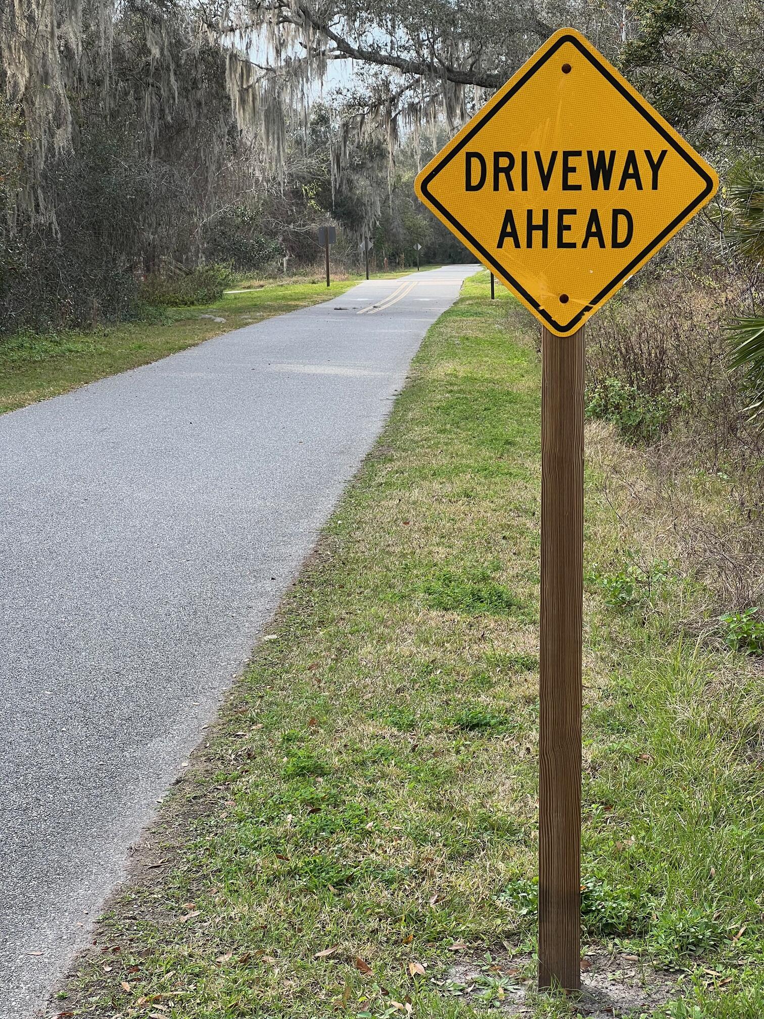
I was surprised to see several private driveways crossing the trail. Please don’t go off the trail to investigate, as these are private properties.
The trail goes through lush tropical forest. Watch for cardinals and other birds and animals. Don’t shout it out but do let your trailmates know if you spot an armadillo![]() .
.
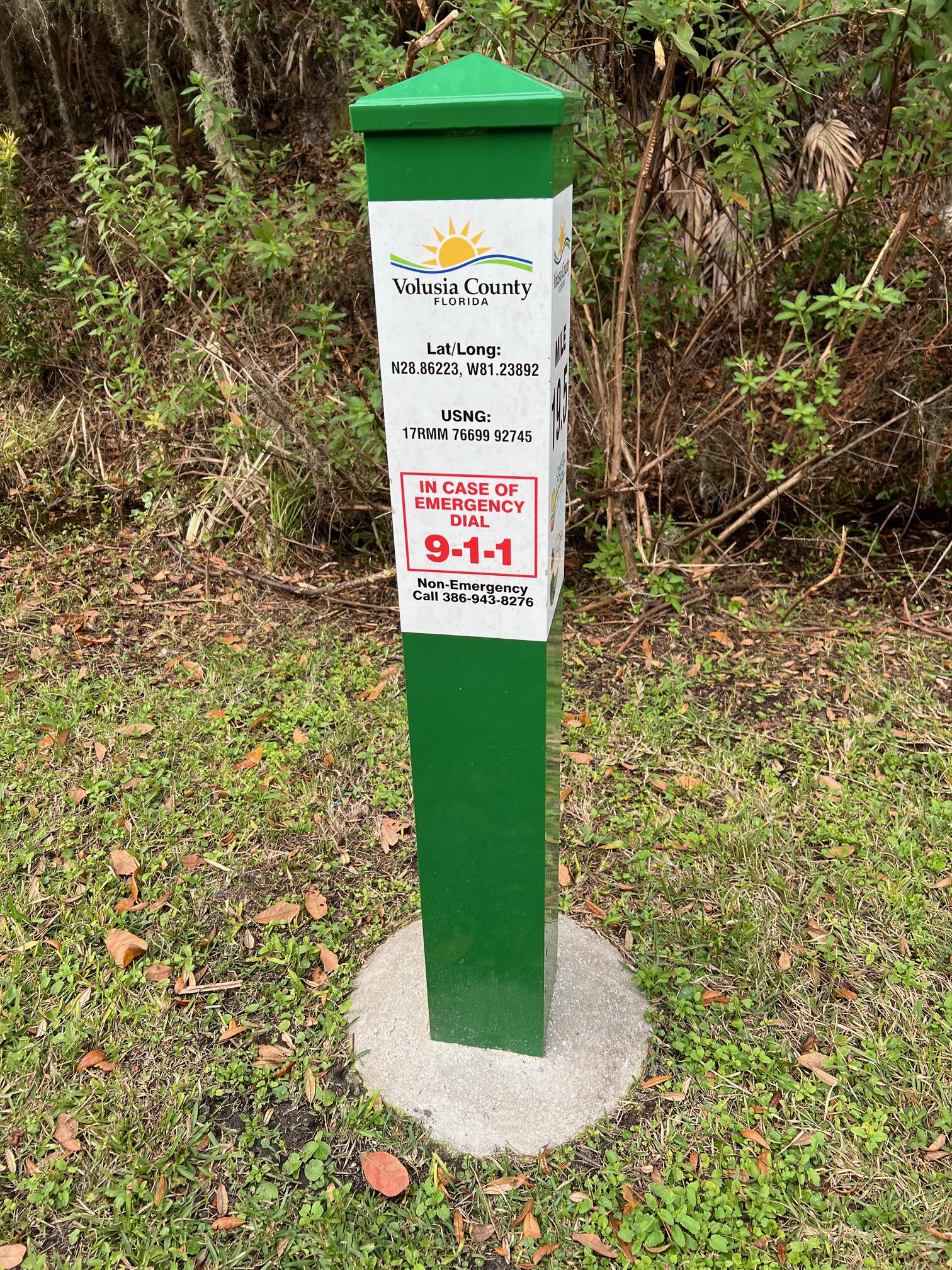
This is a photo of a random trail marker. I wish I had photographed the closest one to the trailhead to help you find it.
The namesake spring is a very short detour between the parking area and the trail itself.
There are many intersecting trails near the Green Springs Parking area. Unless you know the trails well, be sure to use a map.
History
From East Central Regional Rail Trail Management Plan![]() :
:
Purchase of the Green Springs Pathway was explored for nearly 20 years. In late 2001, the East Central Florida Regional Planning Council assisted the counties of Volusia and Brevard in submitting an Application for Acquisition of Land to the Office of Greenways and Trails of the Florida Department of Environmental Protection (“OGT”). Fortunately, this project was ranked high enough to be slated for purchase and OGT began the long and arduous process of surveying the corridor and having it appraised. Due to the nature of such a long‐standing corridor, many title issues had to be resolved. Although the railroad tracks were removed over 50 years ago in many places except in the Titusville/Mims area, where they were only removed two years ago, title to the corridor itself remained in the hands of the Florida East Coast Railway Company (“FEC”). With such a long history of ownership, the railroad right‐of‐way has been left off of title searches hence several private buildings have encroached on the right‐of‐way. Negotiations to deal with these encroachments will be handled fairly and compassionately by seeking win‐win solutions.
Ultimately, nearly the entire corridor was purchased from the FEC for $16 million using Florida Forever funds. Being the longest rail‐to‐trail acquisition in the state of Florida, the final corridor is 50.8 miles long and ranges from 35 to 200 feet wide for a total of 668.35 acres. The purchase closed on December 31, 2007 with the Board of Trustees of the Internal Improvement Trust Fund of the State of Florida (“Trustees”) acquiring fee simple title. Once in public ownership, the trail corridor was leased to OGT for 50 years on April 25, 2008; in September 2008 OGT subsequently provided Volusia County and Brevard County a 50 year sublease to develop and manage the proposed multi‐use trail (see Appendix 1).
Kudos to those with the vision and capability to bring this plan to fruition.
Hiking Solo (and Running, etc.)
There are many trailheads and parking areas along the trail. Suppose you can do a section between trailheads but not out and back. If you don’t have multiple cars to stage at the trailheads, consider using Uber or Lyft to get a ride from where you parked to the other trailhead. Then you can hike, cycle, walk, or roll to your car from there. Since this trail is in a well-populated area, you won’t have long to wait for a ride. I’ve done this several times because I usually hike solo.
Trail Summary
| Distance | 3.57 miles point to point | 7.14 miles out and back |
| Elevation gain | 119 feet | |
| Trail surface | 100% asphalt | |
| Difficulty | Easy for point to point | Moderate for out and back |
| Green Springs Park trailhead | 28.862524, -81.248322 |
Avenza Map
Avenza Map
- Load the PDF map into Avenza app on your smartphone in one of these ways:
- From your smartphone’s browser, tap this link to load the map directly into Avenza.
- From Avenza app’s Import Maps function, scan this QR code.

- Be sure to do this when you have good internet connection. Don’t wait until you are at the trailhead!
For more information about trail maps, see the Maps page.