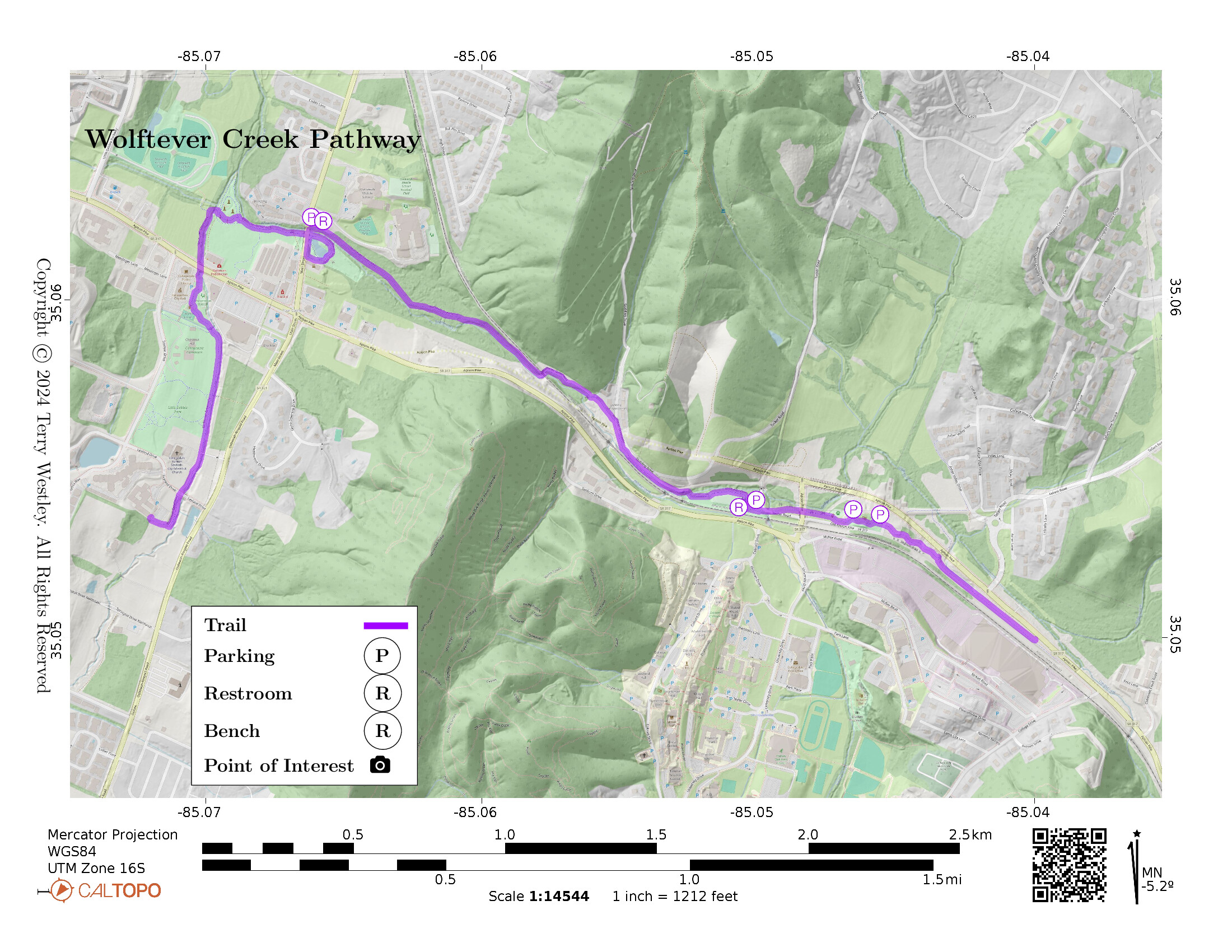
Wolftever Creek Greenway![]() is a 3 mile, asphalt and concrete trail in Collegedale, TN. The trail follows Wolfever Creek along a Norfolk and Southern Railroad bed.
is a 3 mile, asphalt and concrete trail in Collegedale, TN. The trail follows Wolfever Creek along a Norfolk and Southern Railroad bed.
The western terminus is near Morning Pointe of Greenbriar Cove, an assisted living community. The eastern is on Apison Pike near the McKee Foods Corporation plant and converence center. The elevation gain is 159 feet.
As of spring, 2024, there is major road construction work by some of the trail. Happily, the trail is not closed here but there are flagmen at strategic points.
Leave No Trace, Ten Essentials
While you’re enjoying the outdoors, please leave no trace![]() to minimize your impact and preserve these special places for others to use as well. If you’re walking or hiking, please pack the REI ten essentials
to minimize your impact and preserve these special places for others to use as well. If you’re walking or hiking, please pack the REI ten essentials![]() for your own safety. When cycling, consider using this REI checklist
for your own safety. When cycling, consider using this REI checklist![]() . For other activities, review the hiking and biking essentials and use your judgement.
. For other activities, review the hiking and biking essentials and use your judgement.
Parking
You can find parking at Thatcher Switch Recreational Area, at the intersection of the trail and Main Street, near Nature Nook, and near the dog park.
Trail Surface
The trail surface is 100% asphalt and concrete and is in very good condition.
Restrooms
There are public restrooms at Thatcher Switch Recreational Area and at the intersection of the trail and Main Street. The latter are just north of the trail on the east side of Main Street.
Points of Interest
These points of interest are promoted on the Collegedale Parks and Rec![]() website:
website:
- Imagination Station
 : “Children run, play, imagine, interact, and stay busy on playground equipment designed for all ages. The park, located behind City Hall, has a caboose and train platform to explore, sandbox, stationary exercise equipment, pickleball courts, a free library stand located in front of the restrooms, and a rentable pavilion,”
 - A dog park: “We love our dogs! So much in fact, that the community came together to establish the Collegedale Dog Park. Our off-leash dog park provides a great place for our furry friends to run, play, and socialize with their neighbors. Come out and join other responsible dog owners. The park is located at the east end of the Wolftever Greenway by the Nature Nook. Use the following address for driving direction: 5225 Tallant Road Ooltewah, TN 37363,”
- Nature Nook: “Amidst a quiet grove of trees and picturesque landscaping at Tallant Road and Apison Pike, sits a quaint open-air amphitheater. The amphitheater is a gift from Kiwanis Club of Ooltewah-Collegedale and is a great thinking and gathering place. Connected to the Nature Nook is a playground and gazebo with a swing just right for reading and studying. The greenway and dog park are accessible at the turnaround. Restrooms are available at the Economic Development Center beside the turnaround,”
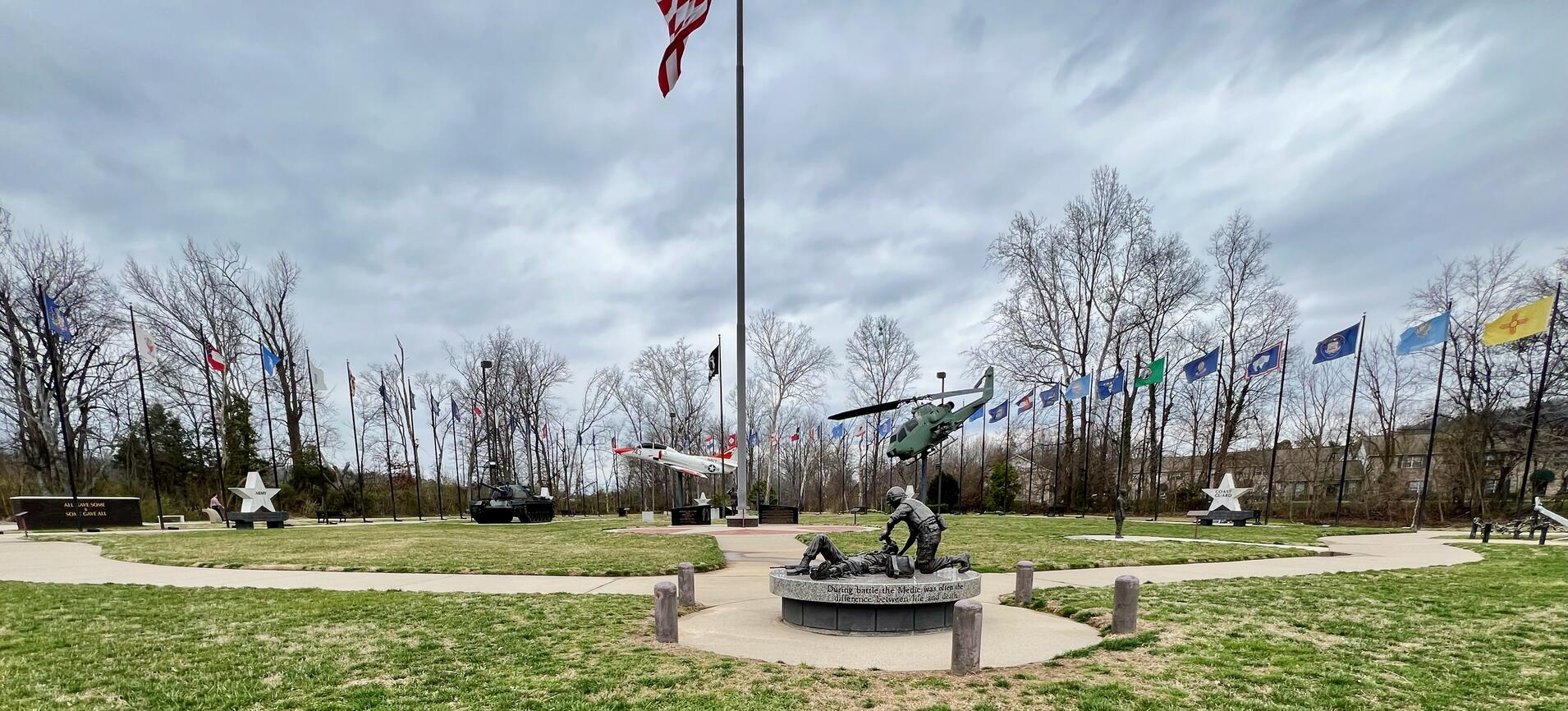
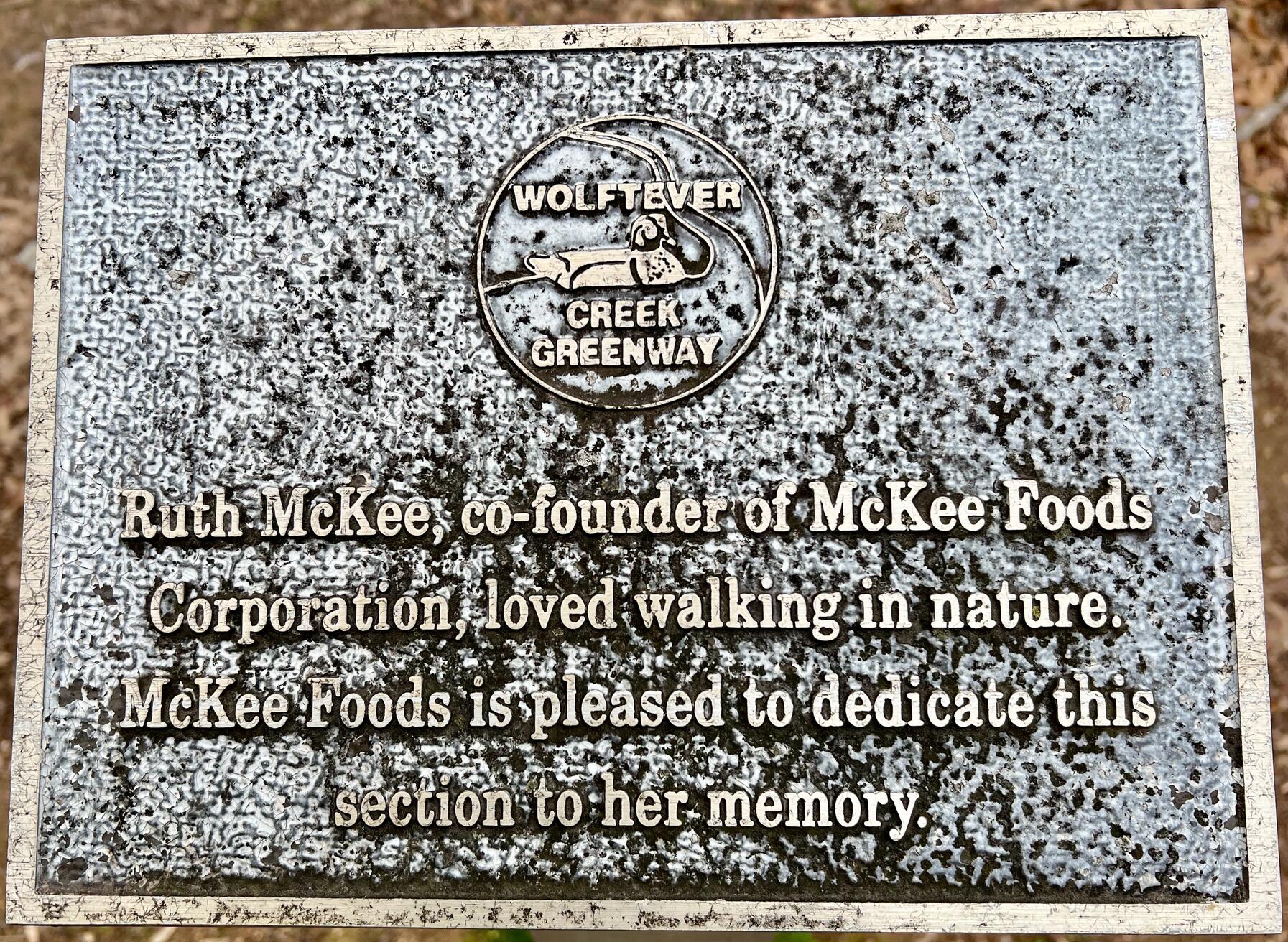
- Veterans Memorial Park: “Collegedale celebrates and commemorates those who have served us in the armed services. Veterans Memorial Park was designed to honor and thank our veterans, while incorporating educational components that are shared with students young and old. Tour the park and view plaques, monuments, flags of all 50 states, sculptures, and military installations as you reflect on those whom have made sacrifices on our nation’s behalf. Veterans Memorial Park is located along Wolftever Creek Greenway facing Apison Pike,” Veterans Memorial Park is right at the intersection where the trail goes south and east from here.
- Thatcher Switch Recreational Area: “This recreational area is situated at the intersection of Tucker Road and Apison Pike. A small playground, multi-use soccer field, and rentable event pavilion are located at this entry area onto the greenway system,” Its address is 5201 Tucker Rd, Ooltewah, TN 37363.
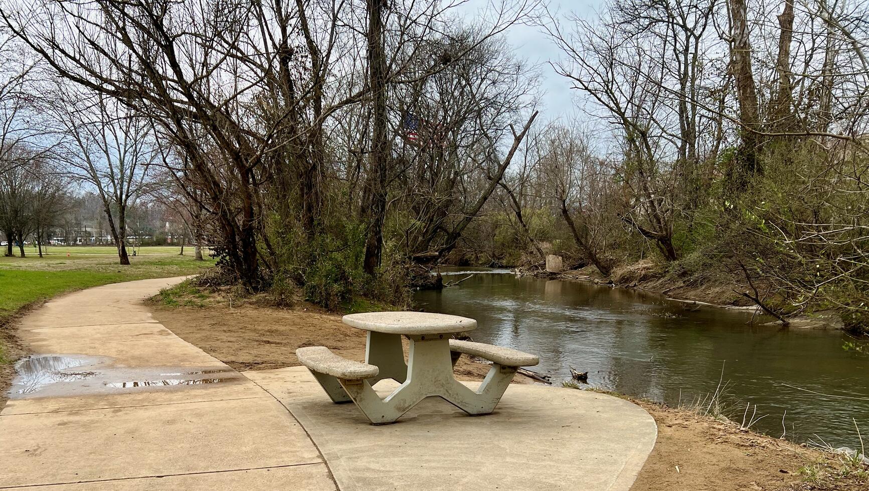
- There is a fishing pond and also fishing in the creek near Main Street bridge.
- You can enjoy several picnic tables and benches along the way.
History
From “Tracing the evolution of the railroad in Collegedale and Ooltewah,” Southern Accent![]() , December 19, 2023:
, December 19, 2023:
Two entities incorporated the Ooltewah and Red Clay Railroad Company and constructed a new railway line, known as the Ooltewah Cutoff, connecting Ooltewah to Red Clay, Georgia, according to a Chattanoogan article
However, disaster struck on Oct. 10, 1882, just one day after the opening of the Ooltewah Cutoff.
“A passenger train, which should have stopped, turned the switch at Ooltewah and proceeded down the new rail line, was blinded by heavy fog, and continued straight ahead at ‘a terrific rate of speed,’ according to the Chattanooga Times story the next day,” McArthur said. “It crashed head-on into a waiting freight train.”
Construction on the trail began in 1998. But then in December, 2022, disaster struck again:
- Watch: Truck carrying 134-foot concrete beam demolished by train, CNN, December 20, 2022
- UPDATE: Train derailed in Collegedale after hitting truck carrying concrete bridge beam, Local 3 News, December 21, 2022
- Repairs to greenway damage from train derailment to restart this month, Southern Accent, September 19, 2023
Hiking Solo (and Running, etc.)
Solo hikers who find themselves able to do the whole point-to-point trail distance but not the out and back may consider using Uber or Lyft to get a ride from where they parked to the other trailhead. Then you can walk to your car from there. Since this trail is in a populated area, you won’t have long to wait for a ride. I’ve done this several times (on other trails) because I usually hike solo.
Trail Summary
| Distance | 3 miles point to point | 6 miles out and back |
| Elevation gain | 159 feet | |
| Trail surface | 100% asphalt and concrete | |
| Difficulty | Easy for point to point | Moderate for out and back |
| Western Trailhead | 35.053587, -85.071843 |
Morning Pointe of Greenbriar Cove |
| Eastern Trailhead | 35.0492356, -85.038875 |
Apison Pike near the McKee Foods Corporation plant |
Avenza Map
Avenza Map
- Load the PDF map into Avenza app on your smartphone in one of these ways:
- From your smartphone’s browser, tap this link to load the map directly into Avenza.
- From Avenza app’s Import Maps function, scan this QR code.

- Be sure to do this when you have good internet connection. Don’t wait until you are at the trailhead!
For more information about trail maps, see the Maps page.