Wasson Way![]() is a 3.6 mile, asphalt rail trail in Cincinnati, OH, built on former railbeds of Cincinnati & Eastern
is a 3.6 mile, asphalt rail trail in Cincinnati, OH, built on former railbeds of Cincinnati & Eastern![]() and Cincinnati Northern
and Cincinnati Northern![]() Railroads.
The western terminus is Montgomery Rd and the eastern is Ault Park.
It proceeds through several neighborhoods including Evanston, Norwood, Hyde Park, Oakley, and Mount Lookout, and provides access to Evanston Playground, Evanston Business District, Rookwood Commons & Pavilion, Hyde Park Plaza, and Ault Park.
The total elevation gain is 190 feet.
It is named after the parallel Wasson Road.
Railroads.
The western terminus is Montgomery Rd and the eastern is Ault Park.
It proceeds through several neighborhoods including Evanston, Norwood, Hyde Park, Oakley, and Mount Lookout, and provides access to Evanston Playground, Evanston Business District, Rookwood Commons & Pavilion, Hyde Park Plaza, and Ault Park.
The total elevation gain is 190 feet.
It is named after the parallel Wasson Road.
Leave No Trace, Ten Essentials
While you’re enjoying the outdoors, please leave no trace![]() to minimize your impact and preserve these special places for others to use as well. If you’re walking or hiking, please pack the REI ten essentials
to minimize your impact and preserve these special places for others to use as well. If you’re walking or hiking, please pack the REI ten essentials![]() for your own safety. When cycling, consider using this REI checklist
for your own safety. When cycling, consider using this REI checklist![]() . For other activities, review the hiking and biking essentials and use your judgement.
. For other activities, review the hiking and biking essentials and use your judgement.
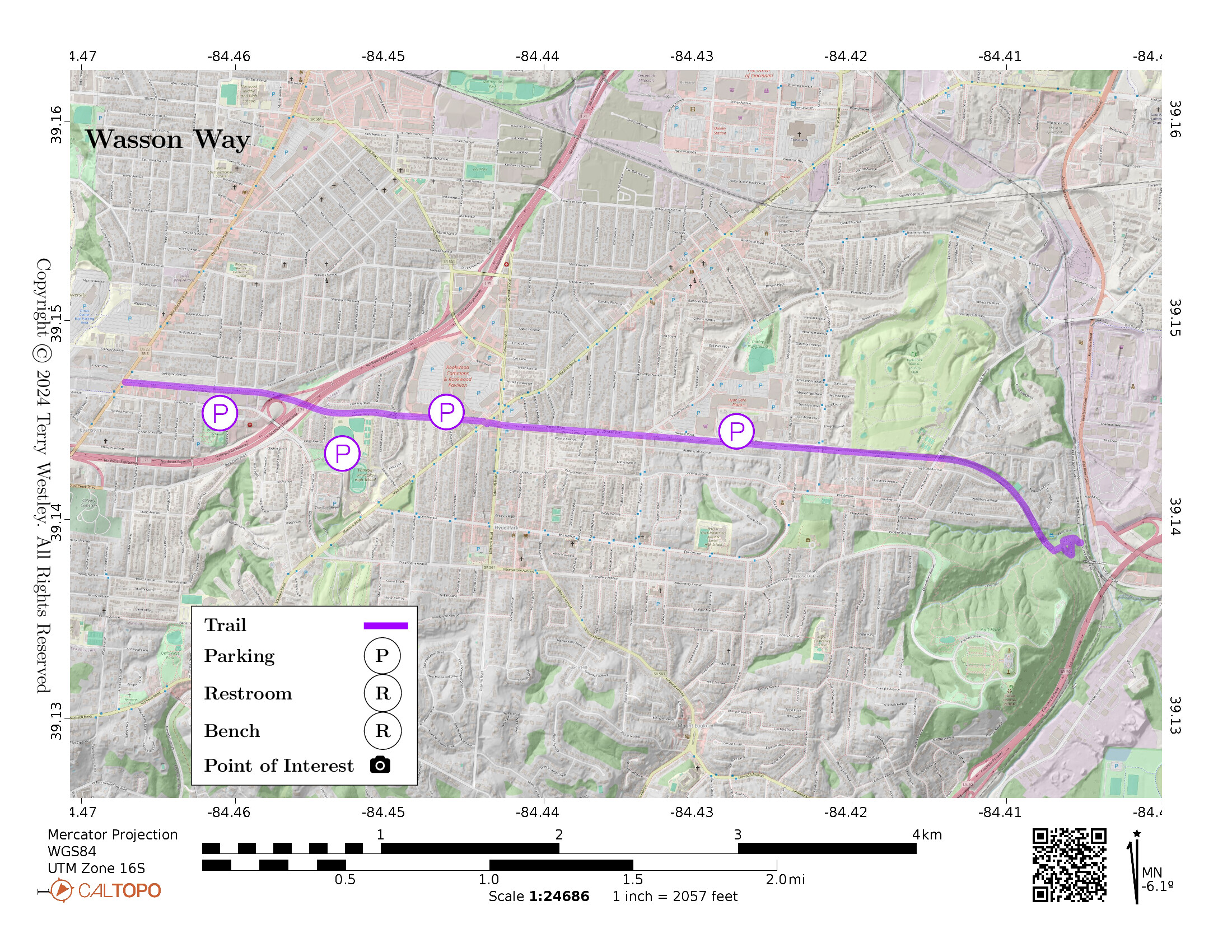
Parking
You can find parking at Evanston Playground (3558 Evanston Ave), Withrow High School (2488 Madison Road), Rookwood Commons (3805 Edwards Rd), and Hyde Park Plaza (3760 Paxton Ave). See the map below.
Trail Surface
The trail surface is 100% asphalt which is in very good condition.
Restrooms
There are no public restrooms at the trailheads or along the trail.
There are many stores in the various plazas along the trail. Lacking a law to the contrary (e.g. Ally’s Law), stores are generally not required to accommodate non-customers.
Points of Interest
Pay close attention to the bridges over streets and especially over I-71. These have been beautifully architected and constructed. Bridges are costly for non-profit trail associations to build or restore, so please appreciate them!
Along the trail, you have access to several plazas where you can shop, eat, and rest. These include Evanston Business District, Rookwood Commons & Pavilion![]() , and Hyde Park Plaza
, and Hyde Park Plaza![]() .
.
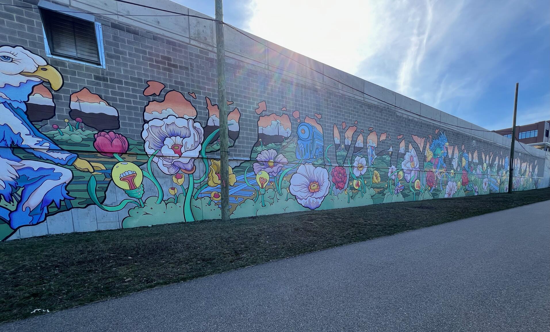
There are multiple murals along the trail and more are planned. Take some time to appreciate them. The one pictured is at Duke Energy Operation Center![]() .
.
Wasson Way even has its very own hotel, the Hampton Inn and Suites by Hilton Cincinnati Midtown Rookwood.
History
Stan Hedeen, Professor Emeritus, Xavier University![]() , writes at Wasson Way History
, writes at Wasson Way History![]() :
:
The Ault Park to Montgomery Road section of Wasson Way is built on the roadbed of the Cincinnati & Eastern, an Ohio railway opened between Portsmouth and Cincinnati in 1884. The railroad’s local passenger stations were at Edwards Road, Elsmere Avenue, and Idlewild, the community that was located where Xavier University stands today. The Ault Park to Idlewild portion of the train route closed in 2009, after which it was purchased by the City of Cincinnati and converted into the main section of Wasson Way.
At Idlewild, Cincinnati & Eastern trains bound for downtown Cincinnati switched onto the tracks of the Cincinnati Northern, an Ohio railway completed between Lebanon and Cincinnati in 1882. The Cincinnati Northern trackage from Idlewild to downtown Cincinnati was abandoned in the 1990s and acquired by the Southwest Ohio Regional Transit Authority (SORTA). The Authority subsequently allowed the roadbed to be used for the section of Wasson Way that starts at Woodburn Avenue and continues into Avondale.
Hiking Solo (and Running, etc.)
Solo hikers who find themselves able to do the whole point-to-point trail distance but not the out and back may consider using Uber or Lyft to get a ride from where they parked to the other trailhead. Then you can walk to your car from there. Since this trail is in a populated area, you won’t have long to wait for a ride. I’ve done this several times (on other trails) because I usually hike solo.
Trail Summary
| Distance | 3.6 miles point to point | 7.2 miles out and back |
| Elevation gain | 190 feet | |
| Trail surface | 100% asphalt | |
| Difficulty | Easy for point to point | Moderate for out and back |
| Western Trailhead | 39.14692, -84.46723 |
Montgomery Road |
| Eastern Trailhead | 39.13886, -84.40511 |
Ault Park |
Avenza Map
Avenza Map
- Load the PDF map into Avenza app on your smartphone in one of these ways:
- From your smartphone’s browser, tap this link to load the map directly into Avenza.
- From Avenza app’s Import Maps function, scan this QR code.

- Be sure to do this when you have good internet connection. Don’t wait until you are at the trailhead!
For more information about trail maps, see the Maps page.