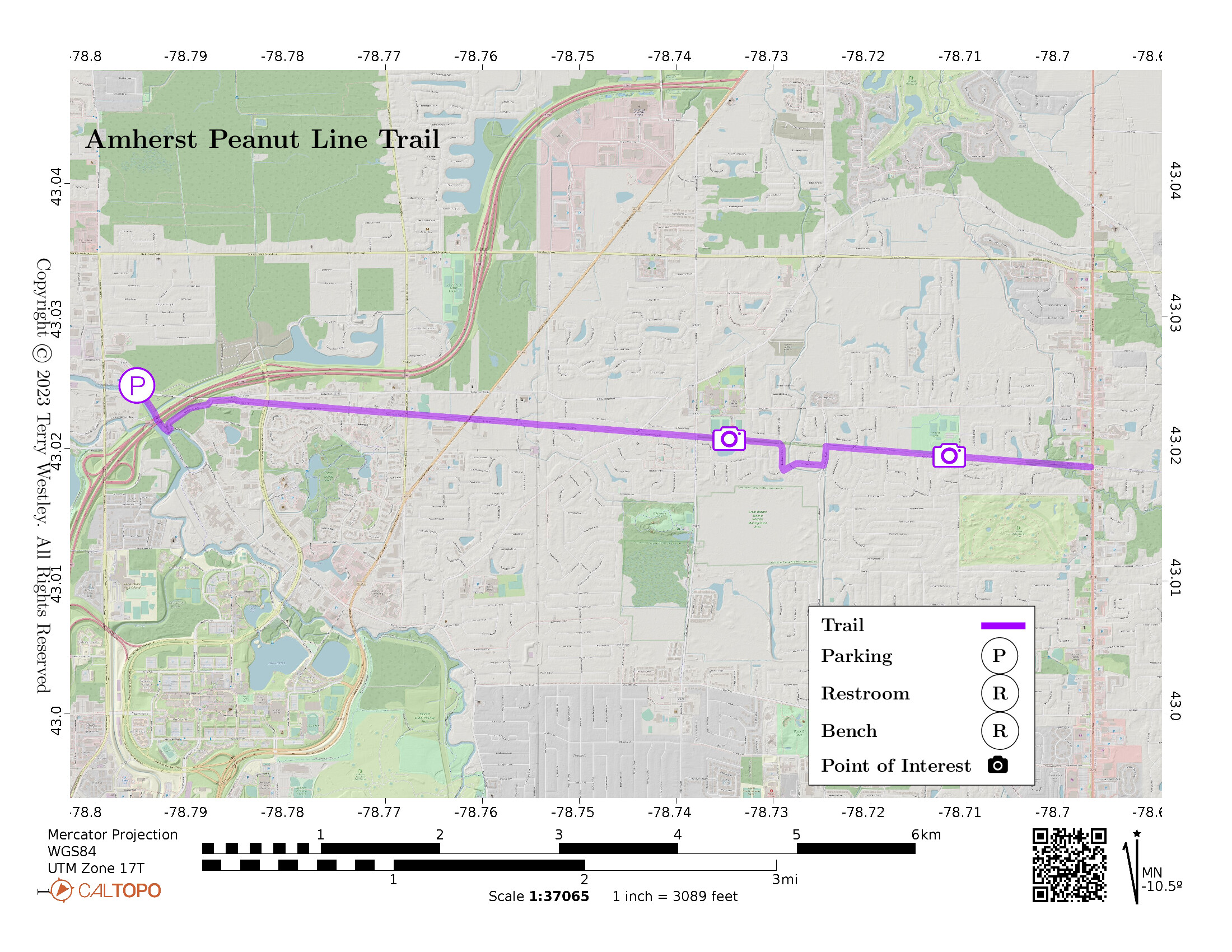
The Amherst Peanut Line Trail is 5.2 miles point to point (10.4 miles out and back) with elevation gain of a mere 33 feet.
It coincides with a portion of the Conservation Trail![]() .
There is a convenient parking lot at 79 Dodge Rd, on the Ellicott Creek Trailway (AKA Amherst Bike Path).
.
There is a convenient parking lot at 79 Dodge Rd, on the Ellicott Creek Trailway (AKA Amherst Bike Path).
Leave No Trace, Ten Essentials
While you’re enjoying the outdoors, please leave no trace![]() to minimize your impact and preserve these special places for others to use as well. If you’re walking or hiking, please pack the REI ten essentials
to minimize your impact and preserve these special places for others to use as well. If you’re walking or hiking, please pack the REI ten essentials![]() for your own safety. When cycling, consider using this REI checklist
for your own safety. When cycling, consider using this REI checklist![]() . For other activities, review the hiking and biking essentials and use your judgement.
. For other activities, review the hiking and biking essentials and use your judgement.
Trail Surface
The trail is mostly uneven grass and the drainage after rain is not great. There are several street crossings with guardrails that have to be climbed over.
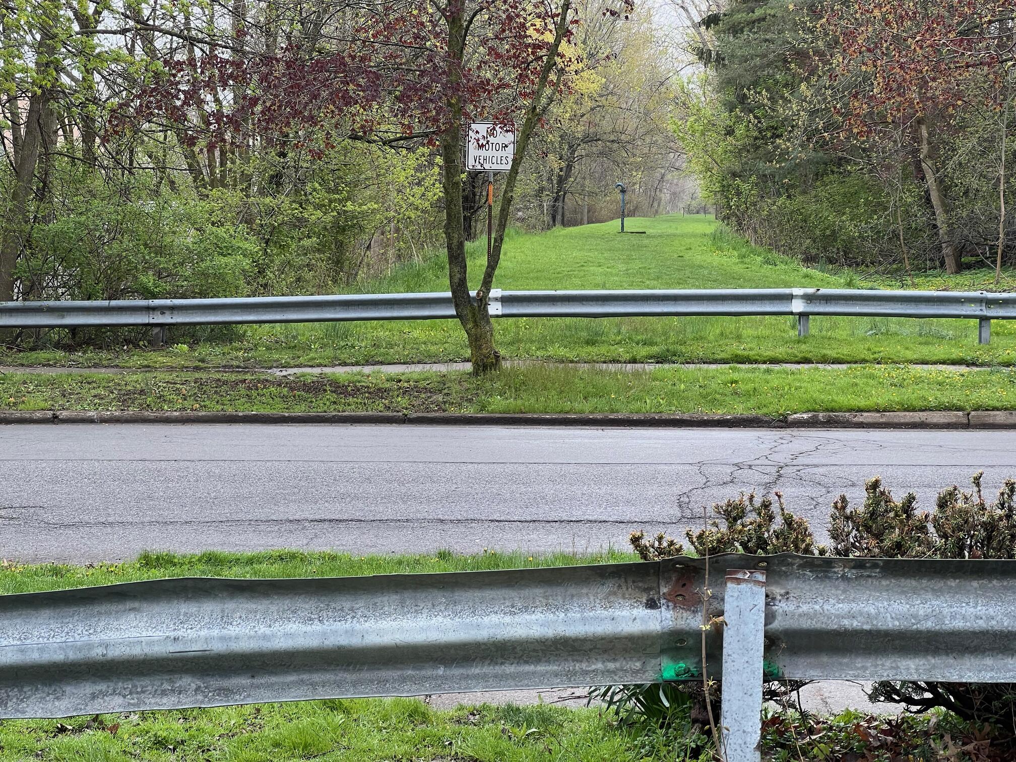
There is a large ditch on the east side of John James Audubon Parkway that must be jumped, waded, or navigated around. If you decide to navigate around, go north to cross at Dodge Rd. It’s not far.
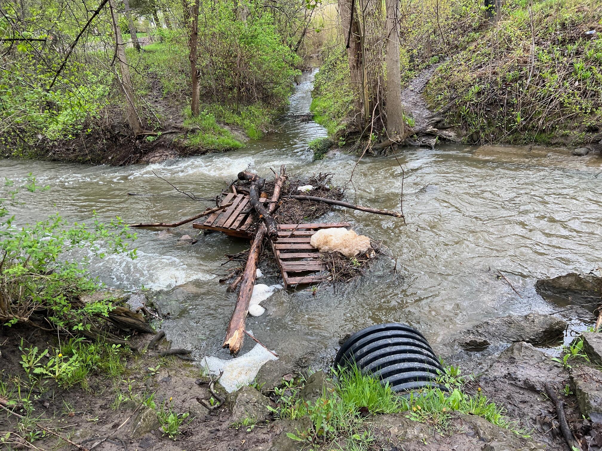
Depending on recent rainfall, the creek between E Pinelake Dr and Youngs Rd may be uncrossable. In that case, detour around it via E Pinelake Dr, Pino Verde Ln, and Youngs Rd.
Please consider carefully whether this trail surface is adequate for your activity.
Restrooms
There are no public restrooms at the trailheads or along the trail.
Points of Interest
Points of interest on the trail include Williamsville North High School soccer and track fields![]() and popular Paradise Park
and popular Paradise Park![]() .
.
History
John G. Sheret writes in the Spring-Summer 2007 edition of “The Crooked Lake Review:”![]()
January 1, 1853, proved to be an exciting day for the residents of Honeoye Falls when the first train of the newly built Canandaigua to Batavia Railroad arrived in the village. Large crowds turned out for the event and everyone was offered a free ride to Batavia and back.
By July 1st of that year the railroad was extended to Niagara Falls, and on July 28th, the first passenger train, operated as an excursion train, ran over the completed road. Historical accounts differ on whether the line was acquired by the New York Central Railroad in 1855 or 1857. In any event it became known as the “Peanut Line” after Dean Richmond, a company vice-president, referred to the acquisition as “only a peanut of a line.” The official New York Central designation for the line was the “Batavia Branch.”
Hiking Solo (and Running, etc.)
Solo hikers who find themselves able to do the whole point-to-point trail distance but not the out and back may consider using Uber or Lyft to get a ride from where they parked to the other trailhead. Then you can walk to your car from there. Since this trail is in a populated area, you won’t have long to wait for a ride. I’ve done this several times (on other trails) because I usually hike solo.
Trail Summary
| Distance | 5.2 miles point to point | 10.4 miles out and back |
| Elevation gain | 33 feet | |
| Trail surface | Mostly grass (some gravel) | |
| Difficulty | Easy | |
| Point of Interest | 43.02113, -78.73529 |
Williamsville North High School soccer and track fields |
| Point of Interest | 43.019378, -78.710884 |
Paradise Park |
| Dodge Rd Parking | 43.024746, -78.795328 |
7 spaces + 1 handicap |
Avenza Map
Avenza Map
- Load the PDF map into Avenza app on your smartphone in one of these ways:
- From your smartphone’s browser, tap this link to load the map directly into Avenza.
- From Avenza app’s Import Maps function, scan this QR code.

- Be sure to do this when you have good internet connection. Don’t wait until you are at the trailhead!
For more information about trail maps, see the Maps page.