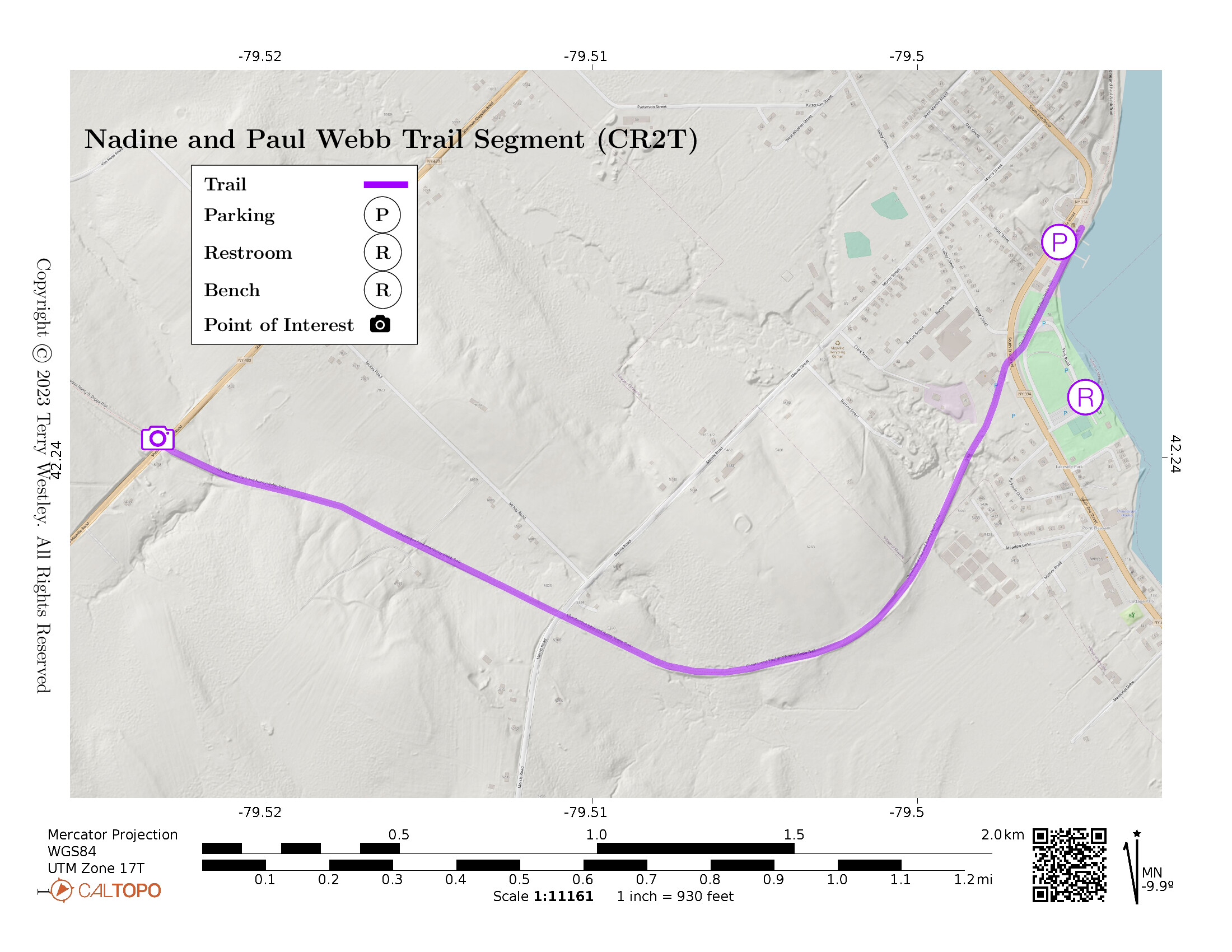
The Nadine and Paul Webb Trail is a segment of the Chautauqua Rails To Trails![]() (CR2T).
The trail starts at the Mayville Depot
(CR2T).
The trail starts at the Mayville Depot![]() on 394 and proceeds for 1.9 miles to State Route 430.
Elevation gain is 138 feet.
on 394 and proceeds for 1.9 miles to State Route 430.
Elevation gain is 138 feet.
Park at the Mayville Depot or in Lakeside Park, both of which are off State Route 394 in Mayville near the north end of Chautauqua Lake.
For most of the trail, there are woods on both sides that are posted no trespassing. When you reach the end of the trail, you will see the Nancy B. Diggs trailhead sign on the other side of State Route 430. On the other hand, starting from the Mayville Depot, you can go north via the Mayville Village Trail
Besides our map below, see also CR2T’s map of the trail![]() .
.
Leave No Trace, Ten Essentials
While you’re enjoying the outdoors, please leave no trace![]() to minimize your impact and preserve these special places for others to use as well. If you’re walking or hiking, please pack the REI ten essentials
to minimize your impact and preserve these special places for others to use as well. If you’re walking or hiking, please pack the REI ten essentials![]() for your own safety. When cycling, consider using this REI checklist
for your own safety. When cycling, consider using this REI checklist![]() . For other activities, review the hiking and biking essentials and use your judgement.
. For other activities, review the hiking and biking essentials and use your judgement.
Trail Surface
The trail is paved from the Mayville Depot to Park Road near South Erie Street. From there to the trailhead sign, it is grass. From the trailhead sign to Morris Road, it is loose gravel.
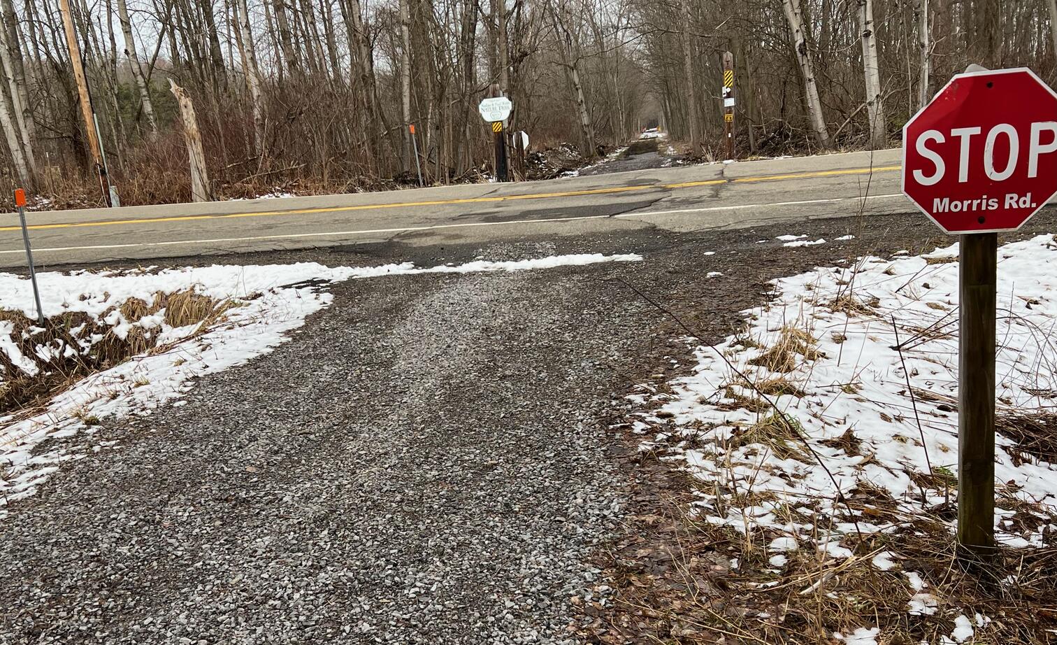
From Morris Road to the trail end at Sherman-Mayville Road (State Route 430), it is dirt (mud depending on season and weather) and grass. In winter, the trail can be pretty torn up due to snowmobile usage.
Please consider carefully whether this trail surface is adequate for your activity.
Restrooms
There are public restrooms in Lakeside Park.
Points of Interest
Points of interest include the Mayville Depot, the Chautauqua Belle![]() , a sternwheeler steam boat, and Lakeside Park.
, a sternwheeler steam boat, and Lakeside Park.
History
William Mohan writes in the August 25, 2019, edition of the Jamestown Post-Journal![]() ,
,
Originally started in 1991, Chautauqua County Rails To Trails has been working to provide means of natural conservation for the community.
At the same time, the group also tries to preserve trails that once served as crucial points of infrastructure on railroad networks in the United States.
Rails To Trails was originally formed by Dr. Bob Berke and attorney John Goodell. However, CR2T president Jim Fincher refers to Goodell as “the spark-plug” that started the organization.
The reason for this is that Goodell learned the former Pennsylvania Railroad (Pennsy) right-of-way from Brocton to Corry, Pa., and Oil City, Pa., (running through Mayville and Sherman) was for sale.
Previously, the line had been the Chautauqua Branch line run by the Pennsy from the late 19th Century to 1968. It then became the property of the Penn Central railroad (a merger with the Pennsy, its rival: New York Central and the New Haven railroads). Due to financial hardships that plagued the company, Penn Central only lasted eight years and the Chautauqua Branch was abandoned in 1975 (the company’s final full year).
Trail Summary
| Distance | 1.9 miles | 3.8 miles out and back |
| Elevation gain | 138 feet | The highest point is the intersection with Rt 430 |
| Trail surface | Asphalt, gravel, grass, dirt | |
| Difficulty | Easy | |
| Point of Interest | 42.24293, -79.49609 |
Lakeside Park |
| Mayville Depot Parking | 42.24489, -79.49565 |
Plenty of parking here and at Lakeside Park |
Note: Coordinate links open in Google Maps.
Avenza Map
Avenza Map
- Load the PDF map into Avenza app on your smartphone in one of these ways:
- From your smartphone’s browser, tap this link to load the map directly into Avenza.
- From Avenza app’s Import Maps function, scan this QR code.

- Be sure to do this when you have good internet connection. Don’t wait until you are at the trailhead!
For more information about trail maps, see the Maps page.