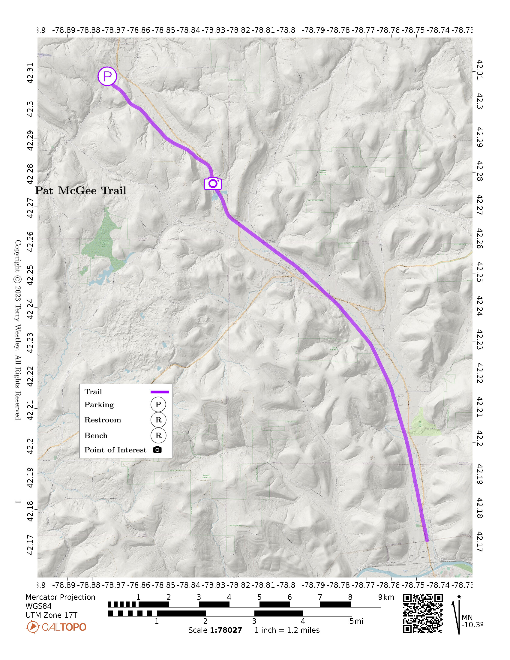
The Pat McGee Trail is a 12.1 mile point to point rail trail from Salamanca to Cattaraugus.
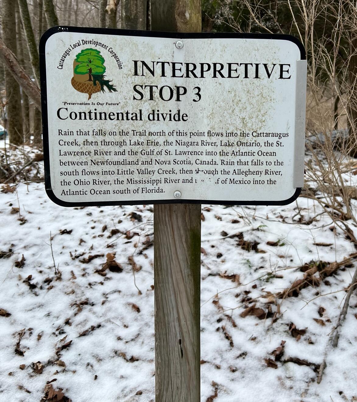
The highest point on the trail is the Eastern Continental Divide about 3 miles
southeast of the Cattaraugus trailhead.
The elevation gain from each end of the trail to the Eastern Continental Divide is 187 feet.
The Cattaraugus trailhead has a small parking lot.
Other parking lots are shown on the New York State Parks, Recreation, and Historic Preservation Pat McGee Trail map![]() .
.
Leave No Trace, Ten Essentials
While you’re enjoying the outdoors, please leave no trace![]() to minimize your impact and preserve these special places for others to use as well. If you’re walking or hiking, please pack the REI ten essentials
to minimize your impact and preserve these special places for others to use as well. If you’re walking or hiking, please pack the REI ten essentials![]() for your own safety. When cycling, consider using this REI checklist
for your own safety. When cycling, consider using this REI checklist![]() . For other activities, review the hiking and biking essentials and use your judgement.
. For other activities, review the hiking and biking essentials and use your judgement.
Trail Surface
The trail is mostly gravel, dirt, and grass. Several sections, including near the Cattaraugus trailhead, can be very muddy after significant rainfall. Most of the trail does have good drainage.
Please consider carefully whether this trail surface is adequate for your activity.
Restrooms
There are no restrooms at the Cattaraugus trailhead. Perhaps there are some at the Pat McGee Trail Parking and Picnic Area in Little Valley or at the Salamanca trailhead.
Points of Interest
The Eastern Continental Divide is encountered on this trail about 3 miles
southeast of the Cattaraugus trailhead.
This and several other points of interest are shown on the delightful New York State Parks, Recreation, and Historic Preservation
Pat McGee Trail map![]() .
.
There is a Lean-to and picnic table approximately 0.6 miles southeast of the Cattaraugus trailhead.
History
From the Pat McGee Trail description![]() by New York State Parks, Recreation, and Historic Preservation:
by New York State Parks, Recreation, and Historic Preservation:
The 12.1-mile Pat McGee Trail in Cattaraugus County connects the city of Salamanca and village of Cattaraugus. This multi-use trail along a former rail bed [ed. Erie Lackawanna Railroad] has connections with the current Finger Lakes Trail and the North Country Trail, which provide links to Allegany State Park in New York State and Allegany National Forest in Pennsylvania.
Named for former state Sen. Pat McGee, the trail opened in 2005 and is used for bicycling, hiking, snowmobiling, and horseback riding. It features a 1.8-acre community park with pavilion and two gazebos in Little Valley, along with five trailheads with parking areas. It also contains six former rail bridges that were rehabilitated for trail use.
The trail runs from the City of Salamanca line, through the Town of Salamanca; the village and town of Little Valley; and the towns of Mansfield and New Albion; ending at Leon Road just outside the Village of Cattaraugus.
Hiking Solo (and Running, etc.)
Solo hikers who find themselves able to do the whole point-to-point trail distance but not the out and back may consider using Uber or Lyft to get a ride from where they parked to the other trailhead. Since this trail is in a less populated area, you may have to wait 15 minutes or more for a ride or you may not get a ride at all. I’ve done this several times because I usually hike solo.
Trail Summary
| Distance | 12.1 miles | 24.2 miles out and back |
| Elevation gain | 187 feet | |
| Trail surface | Gravel, dirt, and grass | |
| Difficulty | Easy | |
| Point of Interest | 42.27682, -78.83160 |
Eastern Continental Divide |
| Cattaraugus trailhead parking | 42.30858, -78.87392 |
About 5 spaces, not paved, not striped |
Avenza Map
Avenza Map
- Load the PDF map into Avenza app on your smartphone in one of these ways:
- From your smartphone’s browser, tap this link to load the map directly into Avenza.
- From Avenza app’s Import Maps function, scan this QR code.

- Be sure to do this when you have good internet connection. Don’t wait until you are at the trailhead!
For more information about trail maps, see the Maps page.