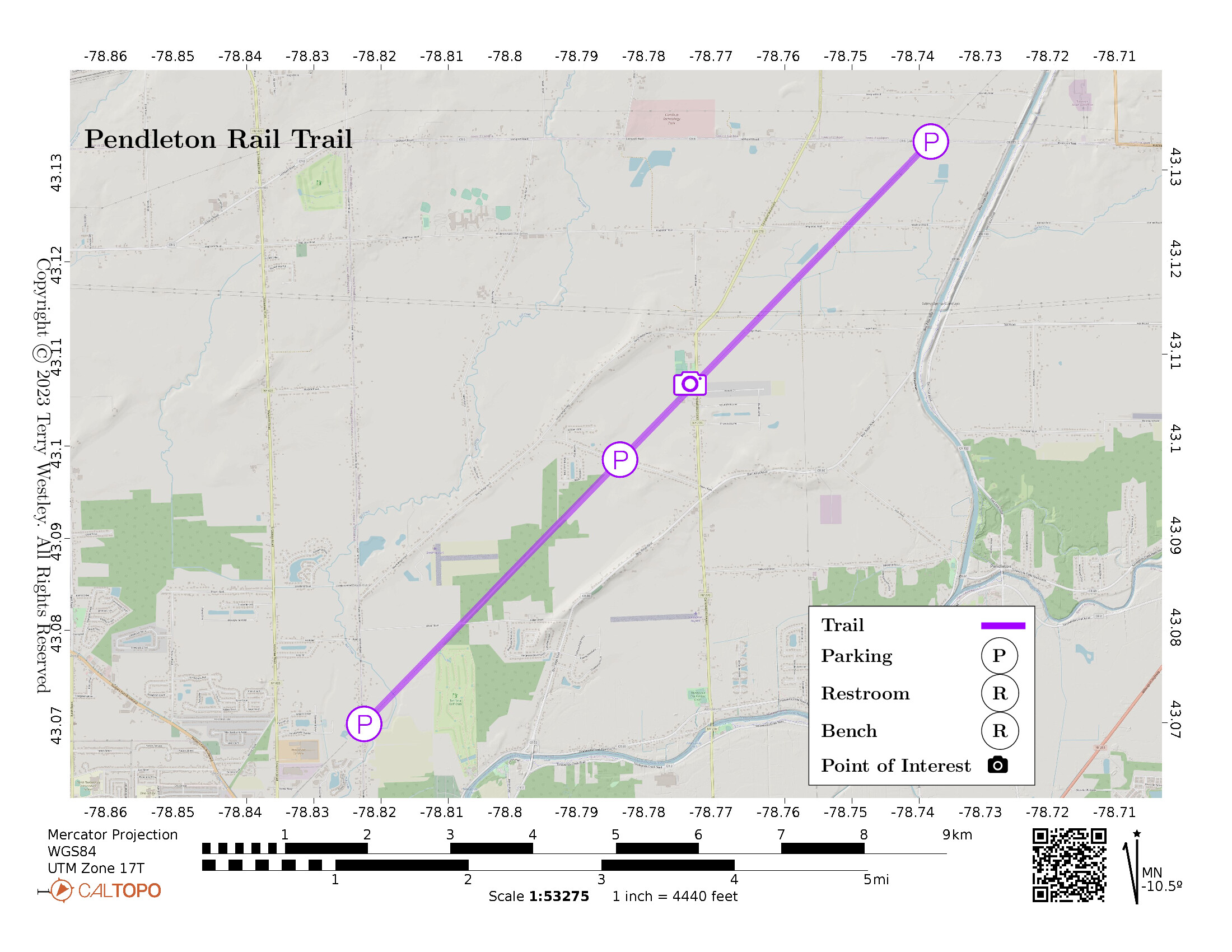
The Pendleton Rail Trail is 6.1 miles point to point (12.2 miles out and back), stretching from its trailhead on Townline Road at the Town of Pendleton border to the terminus at the Town of Pendleton northern border on Lockport Road. The northern terminus coincides with the southern trailhead of the Lockport Rail Trail.
Leave No Trace, Ten Essentials
While you’re enjoying the outdoors, please leave no trace![]() to minimize your impact and preserve these special places for others to use as well. If you’re walking or hiking, please pack the REI ten essentials
to minimize your impact and preserve these special places for others to use as well. If you’re walking or hiking, please pack the REI ten essentials![]() for your own safety. When cycling, consider using this REI checklist
for your own safety. When cycling, consider using this REI checklist![]() . For other activities, review the hiking and biking essentials and use your judgement.
. For other activities, review the hiking and biking essentials and use your judgement.
Trail Surface
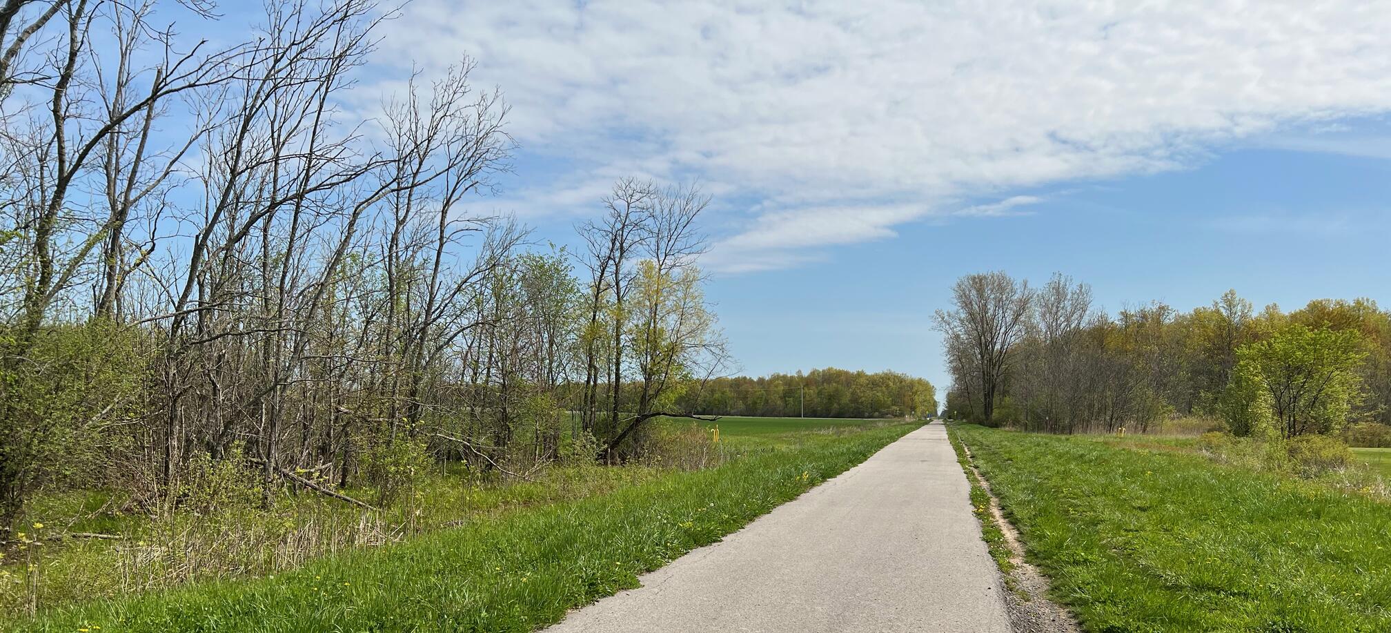
The trail is well paved from the Townline Road trailhead to Killian Road. It is wide and in good condition for about 3.5 miles.
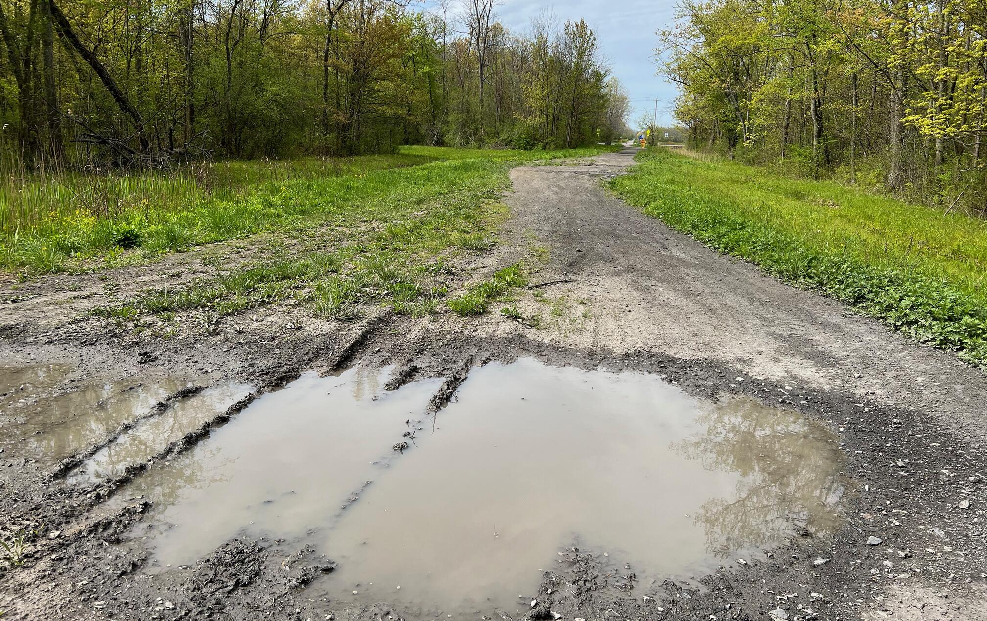
Starting at Killian Road, the trail is very poor. It’s just a dirt trail with very deep ruts filled with mud and/or pooled water. Once the water and mud dries up, you’ll still be navigating the deep ruts.
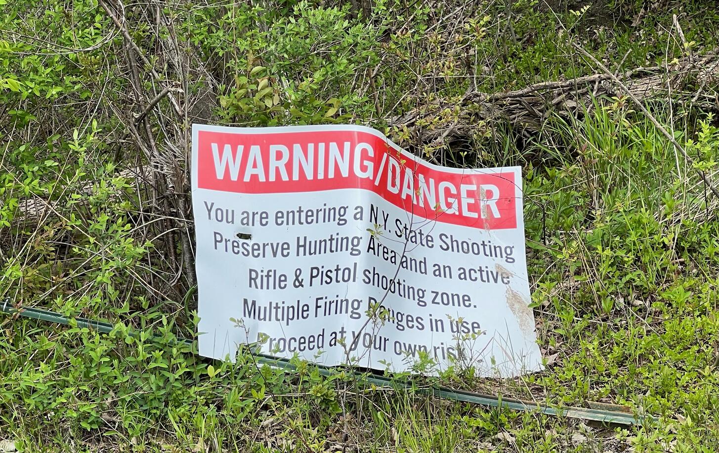
This may be partly due to opposition by the Tonawanda Sportsman’s Club which
operates a gun range near the trail. In the Aug 11, 2016, edition![]() ,
the Niagara Gazette reports “Members of the Tonawanda Sportman’s Club
have concerns about the trail running on town property. Several members
spoke at the July town board meeting, concerned about public safety.”
,
the Niagara Gazette reports “Members of the Tonawanda Sportman’s Club
have concerns about the trail running on town property. Several members
spoke at the July town board meeting, concerned about public safety.”
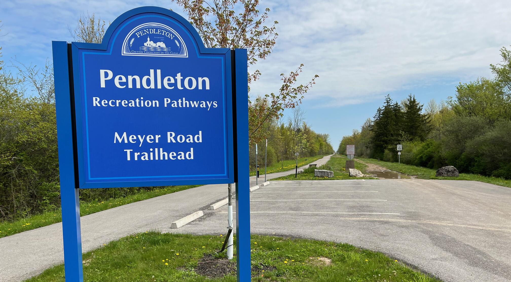
At Meyer Road, the surface is paved again and not too bad. Beyond Mapelton Road to the Lockport Road terminus, it is paved but poor and well worn.
From Killian Road to the terminus on Lockport Road, Pendelton Rail Trail shares the rail bed with an ATV trail.
Please consider carefully whether this trail surface is adequate for your activity.
Restrooms
There are no public restrooms at the trailheads or along the trail.
Points of Interest
The significant point of interest along the trail is the Pendleton water tower.
History
From 2021 Addendum to the Pendleton Town Parks Master Plan of 2007![]() :
:
Pendleton Town Park is also the main trailhead for Pendleton’s Rails-to- Trails, constructed over the past 15 years or so along the abandoned railbed of the former Erie-Lackawanna Railroad Line, and passing along the southern edge of the park. The first three phases, begun in 2005 with a matching grant from the New York State Office of Parks, Recreation, and Historic Preservation, constructed 3.3 miles of asphalt trail along the old Erie Railroad lines traversing through the center of Town from Mapleton Road to Meyer Road.
In 2013 the Town was awarded a NYSDOT grant for Phase IV and constructed additional asphalt non- motorized trail from Killian Road to Townline Road. The Town looks to further expand both non-motorized and motorized trail improvements where feasible.
Hiking Solo (and Running, etc.)
Solo hikers who find themselves able to do the whole point-to-point trail distance but not the out and back may consider using Uber or Lyft to get a ride from where they parked to the other trailhead. Since this trail is in a less populated area, you may have to wait 15 minutes or more for a ride or you may not get a ride at all. I’ve done this several times because I usually hike solo.
Trail Summary
| Distance | 6.1 miles point to point | 12.2 miles out and back |
| Elevation gain | 27 feet | |
| Trail surface | Asphalt, dirt, ruts | |
| Difficulty | Easy | |
| Point of Interest | 43.10682, -78.77405 |
Pendleton water tower |
| Townline Road Parking | 43.06986, -78.82249 |
4 spaces + 1 handicap, paved and striped |
| Meyer Road Parking | 43.09854, -78.78445 |
4 spaces + 1 handicap, paved and striped |
| Lockport Road Parking | 43.13308, -78.73821 |
3-4 spaces, paved, not striped |
Avenza Map
Avenza Map
- Load the PDF map into Avenza app on your smartphone in one of these ways:
- From your smartphone’s browser, tap this link to load the map directly into Avenza.
- From Avenza app’s Import Maps function, scan this QR code.

- Be sure to do this when you have good internet connection. Don’t wait until you are at the trailhead!
For more information about trail maps, see the Maps page.