The Town of Tonawanda Youth, Parks & Recreation![]() reports, “This 3.9 mile trail is composed of two segments on top of a former railroad bed in the Town of Tonawanda and the City of Tonawanda.”
reports, “This 3.9 mile trail is composed of two segments on top of a former railroad bed in the Town of Tonawanda and the City of Tonawanda.”
The town has a useful map![]() which identifies points of interest in the town.
The trail even has its own Facebook page
which identifies points of interest in the town.
The trail even has its own Facebook page![]() .
The celebration of trail completion
.
The celebration of trail completion![]() highlighted new technology implemented for crosswalks at Sheridan Dr,
Englewood Avenue and Brighton Road.
highlighted new technology implemented for crosswalks at Sheridan Dr,
Englewood Avenue and Brighton Road.
The south end of Tonawanda Rail Trail connects to the north end of the North Buffalo Rails to Trails at Kenmore Ave.

Leave No Trace, Ten Essentials
While you’re enjoying the outdoors, please leave no trace![]() to minimize your impact and preserve these special places for others to use as well. If you’re walking or hiking, please pack the REI ten essentials
to minimize your impact and preserve these special places for others to use as well. If you’re walking or hiking, please pack the REI ten essentials![]() for your own safety. When cycling, consider using this REI checklist
for your own safety. When cycling, consider using this REI checklist![]() . For other activities, review the hiking and biking essentials and use your judgement.
. For other activities, review the hiking and biking essentials and use your judgement.
Trail Surface
The trail is completely paved and well maintained with parking lots at both ends that have accessible curbs.
Please consider carefully whether this trail surface is adequate for your activity.
Restrooms
There are no public restrooms at the trailheads or along the trail.
Points of Interest
Here’s a surprise along the trail: a disco ball tree “in loving memory of Walter and Carol Kuziak.”
History
From Town of Tonawanda Youth, Parks & Recreation![]() :
:
The railroad corridor was operated for both freight and passenger service dating back to the 1880’s. Two track systems were in place. A westerly set of tracks was primarily operated for passenger and freight service by a succession of companies beginning with New York & Erie Railroad Co., thru the Erie-Lackawanna railway to 1968. The International Railway Company operated passenger service between Buffalo and Niagara falls from about 1918 to 1937 on the easterly set of tracks. In 1988, the NFTA acquired the right-of-way from the Consolidated Rail Corporation thru New York State legislation. This trail is contracted atop the westerly railroad bed.
In 2002, Erie County initiated the rail to trail project, seeking federal funding and working with partners at the New York State Department of Transportation, NFTA, Town of Tonawanda and the City of Tonawanda on the project planning and funding mechanisms as well as the operation and maintenance needs. This trail, constructed in 2016 by Erie County, is operated by the Town of Tonawanda and City of Tonawanda in their respective jurisdictions thru a cooperative agreement with the NFTA.
Hiking Solo (and Running, etc.)
Solo hikers who find themselves able to do the whole point-to-point trail distance but not the out and back may consider using Uber or Lyft to get a ride from where they parked to the other trailhead. Then you can walk to your car from there. Since this trail is in a populated area, you won’t have long to wait for a ride. I’ve done this several times (on other trails) because I usually hike solo.
Trail Summary
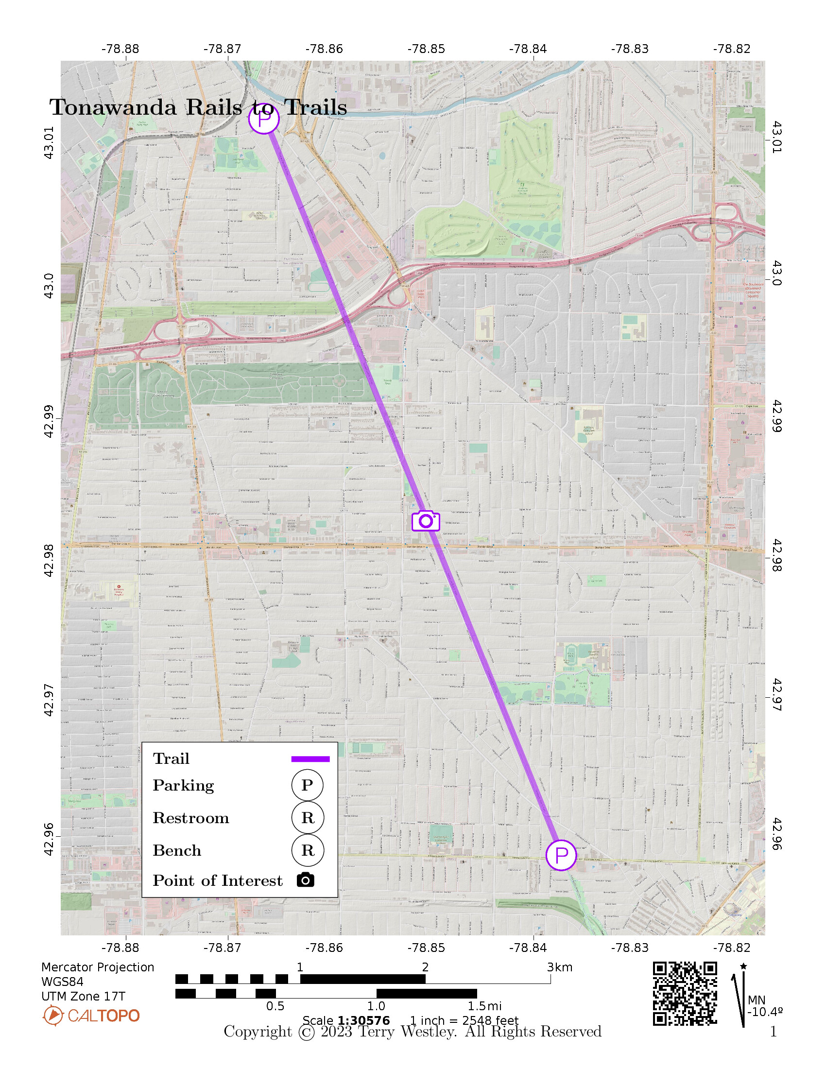
| Distance | 4 miles point to point | 8 miles out and back |
| Elevation gain | 7 feet | |
| Trail surface | Asphalt | |
| Difficulty | Easy | |
| Point of Interest | 42.98268, -78.85057 |
Disco ball tree |
| State Street Parking | 43.01154, -78.86647 |
5 spaces + 2 handicap, paved, striped |
| Kenmore Ave Parking | 42.95865, -78.83729 |
6 spaces + 2 handicap, paved, striped |
Avenza Map
Avenza Map
- Load the PDF map into Avenza app on your smartphone in one of these ways:
- From your smartphone’s browser, tap this link to load the map directly into Avenza.
- From Avenza app’s Import Maps function, scan this QR code.

- Be sure to do this when you have good internet connection. Don’t wait until you are at the trailhead!
For more information about trail maps, see the Maps page.