
The Nancy B. Diggs Trail is a segment of the Chautauqua Rails To Trails (CR2T)![]() .
The CR2T Trail Segments page
.
The CR2T Trail Segments page![]() says, the trail “begins at Hannum Road and runs northward past Bentley Road to State Route 430, passing through woodland and offering first peeks at the agricultural diversity of the area.”
The trail is 1.4 miles point to point (2.8 out and back) with an elevation gain of 92 feet.
says, the trail “begins at Hannum Road and runs northward past Bentley Road to State Route 430, passing through woodland and offering first peeks at the agricultural diversity of the area.”
The trail is 1.4 miles point to point (2.8 out and back) with an elevation gain of 92 feet.
The CR2T’s map of the trail![]() shows the trail’s location near Mayville, NY.
The only available parking is a few spots at the beginning of the trail.
It is not paved and not striped.
shows the trail’s location near Mayville, NY.
The only available parking is a few spots at the beginning of the trail.
It is not paved and not striped.
Leave No Trace, Ten Essentials
While you’re enjoying the outdoors, please leave no trace![]() to minimize your impact and preserve these special places for others to use as well. If you’re walking or hiking, please pack the REI ten essentials
to minimize your impact and preserve these special places for others to use as well. If you’re walking or hiking, please pack the REI ten essentials![]() for your own safety. When cycling, consider using this REI checklist
for your own safety. When cycling, consider using this REI checklist![]() . For other activities, review the hiking and biking essentials and use your judgement.
. For other activities, review the hiking and biking essentials and use your judgement.
Trail Surface
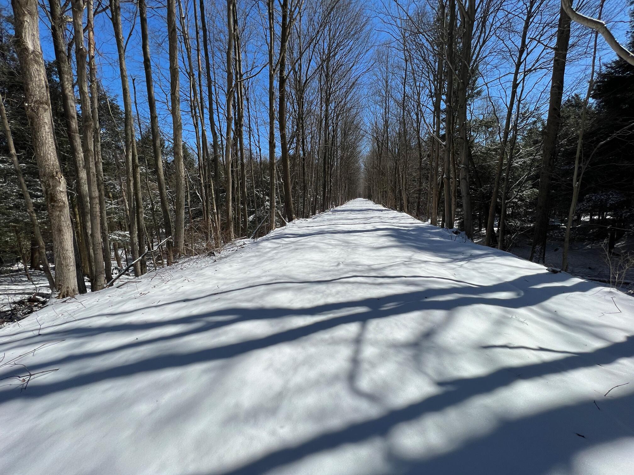
The trail surface is earth and grass and a little bit of gravel. There is a low section near the end of the trail that may have pooled water if it has rained recently. The trail has very little elevation gain except at the last portion that comes upon Route 430. Here there is a short steep descent to Route 430. But it’s the end of trail and can be avoided by just turning around. Only if you’re planning to cross the road and go on to the Nadine and Paul Webb Trail will you have to traverse the steep part.
The trail is great for skiing and snowshoeing in the winter.
Please consider carefully whether this trail surface is adequate for your activity.
Restrooms
There are no public restrooms at the trailheads or along the trail.
Points of Interest
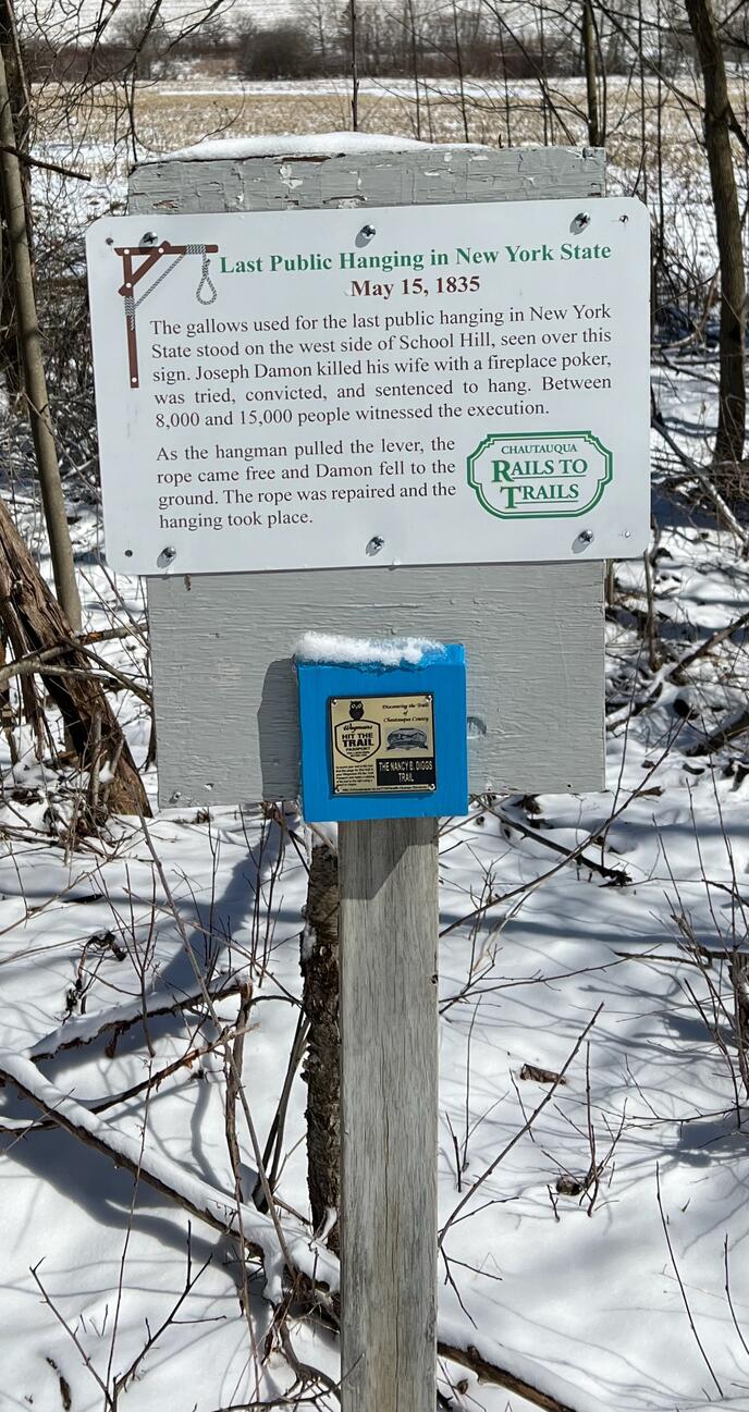
This was a huge surprise to me on the trail: a sign memorializing the last public hanging in New York State.
History
From private communication (Mar 8, 2023) from Wendy Lewellen, Secretary, Chautauqua Rails to Trails:
Nancy’s husband Matthew financed the purchase of the trail property in 1998 through his foundation and named it after his wife to honor her. They live in Dayton, Ohio, but have lived in their home at Chautauqua for decades. His friendship with Les Johnson who used to own Hollyloft Ski and Bike and who worked for Chautauqua Rails to Trails for years, was the connection. The couple were active cyclists and hikers. To know more about her, check her website, Nancy Brown Diggs
, successful nonfiction writer. They still come to Chautauqua every summer and are wonderful people.
Trail Summary
| Distance | 1.4 miles | 2.8 miles out and back |
| Elevation gain | 92 feet | |
| Trail surface | Mostly earth and grass and | a little bit of gravel |
| Difficulty | Easy | |
| Point of Interest | 42.241342, -79.525405 |
Sign of last public hanging in New York |
| Parking Lot | 42.24057, -79.54788 |
2-3 spaces, not paved, not striped |
Avenza Map
Avenza Map
- Load the PDF map into Avenza app on your smartphone in one of these ways:
- From your smartphone’s browser, tap this link to load the map directly into Avenza.
- From Avenza app’s Import Maps function, scan this QR code.

- Be sure to do this when you have good internet connection. Don’t wait until you are at the trailhead!
For more information about trail maps, see the Maps page.
