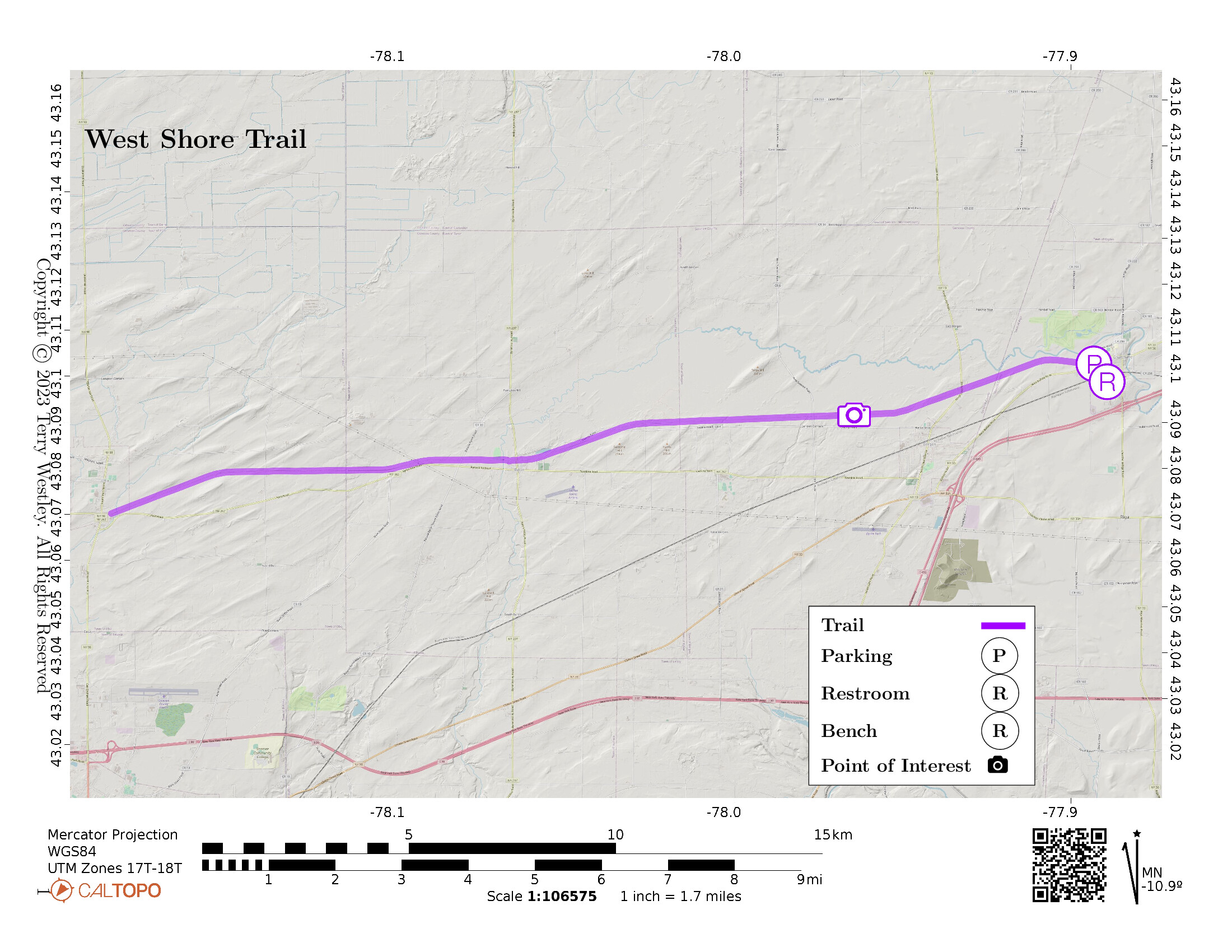
The West Shore Trail proceeds from its trailhead on West Buffalo Street, Churchville, NY, westward for 8.8 miles to its terminus in Byron, NY. The total out and back mileage is 17.6 miles.
The trailhead has a small parking lot, restrooms, and a caboose repainted in its original Chessie System colors![]() .
Trailhead signs describe the history of the caboose in America and some great pictures of this one in service and being installed at the trailhead.
.
Trailhead signs describe the history of the caboose in America and some great pictures of this one in service and being installed at the trailhead.

It’s not a trail for quiet contemplation. Most of the trail has large bushes and trees on each side so it’s hard to see the wetlands, bogs, and swamps. But plenty of songbirds give evidence to the (mostly) unseen landscape. Meanwhile, there is an almost constant sound of the singing of the rails, rattling cars, and train horns.
Leave No Trace, Ten Essentials
While you’re enjoying the outdoors, please leave no trace![]() to minimize your impact and preserve these special places for others to use as well. If you’re walking or hiking, please pack the REI ten essentials
to minimize your impact and preserve these special places for others to use as well. If you’re walking or hiking, please pack the REI ten essentials![]() for your own safety. When cycling, consider using this REI checklist
for your own safety. When cycling, consider using this REI checklist![]() . For other activities, review the hiking and biking essentials and use your judgement.
. For other activities, review the hiking and biking essentials and use your judgement.
Trail Surface
The trail surface is mostly ballast from the trailhead west to the intersection with Route 19. Beyond route 19, it becomes easier with small gravel. It is also wider than most trails, as much as 20 feet. There are several road intersections, all of which are the same level as the trail.
Please consider carefully whether this trail surface is adequate for your activity.
Restrooms
There are public restrooms in the small depot at the West Church Street parking lot.
Points of Interest
Some unusual sights you will see on the trail include
- snowmobile trail signs,
- large concrete pads in the middle of the trail,
- US Department of the Interior Registered National Landmark for Bergen Swamp,
- “Access by written Permission only” in addition to the usual “Posted No Trespassing” signs,
- “Warning Live Feed Surveillance Cameras in use, No Trespassing” sign,
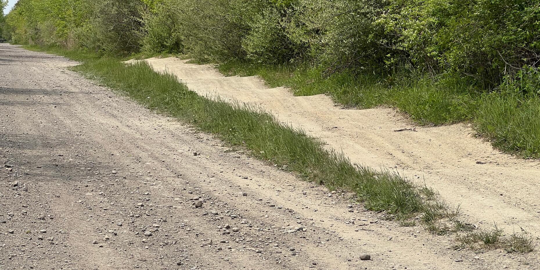
- snowmobile moguls,
- tree stand or tree house, and
- a geocache called “Leap onto the West Shore.”
Did you know snowmobile trails have moguls? Sometimes they are an undesired byproduct of driving snowmobiles in the snow, but these look intentional.
History
The West Shore Railroad was opened in the 1880’s as competition to the New York Central (NYC) Railroad and ran parallel to the NYC. There’s much more history of the railway on the trailhead signs.
In A New Path to our Past![]() , Ron Belczak, Village Historian, wrote:
, Ron Belczak, Village Historian, wrote:
Hoping to create competition, the West Shore ran for about four short years before it was forced into bankruptcy and then acquired by William Vanderbilt, owner of the New York Central Railroad.
Trains continued along these tracks until 1959 when the line was officially discontinued and the rails in the area were removed sometime in the early 1960’s.
Another rail trail built on the West Shore Line is the Westshore Trail Extension in Clarence, NY.
Trail Summary
| Distance | 8.8 miles point to point | 17.6 miles out and back |
| Elevation gain | 105 feet | |
| Trail surface | Ballast and gravel | |
| Difficulty | Easy | |
| Point of Interest | 43.091617, -77.964378 |
Snowmobile moguls |
| West Church St Parking | 43.10278, -77.89285 |
5 spaces, paved, striped |
Avenza Map
Avenza Map
- Load the PDF map into Avenza app on your smartphone in one of these ways:
- From your smartphone’s browser, tap this link to load the map directly into Avenza.
- From Avenza app’s Import Maps function, scan this QR code.

- Be sure to do this when you have good internet connection. Don’t wait until you are at the trailhead!
For more information about trail maps, see the Maps page.