If you’re looking for easy hikes in Chautauqua County, NY, look at these rail trails. A rail trail is a trail built on a former railroad bed. They are great for running, cycling and walking. The asphalt ones may be better for rolling, rollerblading, and pushing a stroller. With adequate snowfall, all are good for skiing and snowshoeing. Please consider carefully which trails are suitable for your activity.
Chautauqua Rails To Trails (CR2T)![]() is a not for profit entity that works to convert abandoned railbeds in Chautauqua County, NY, into trails.
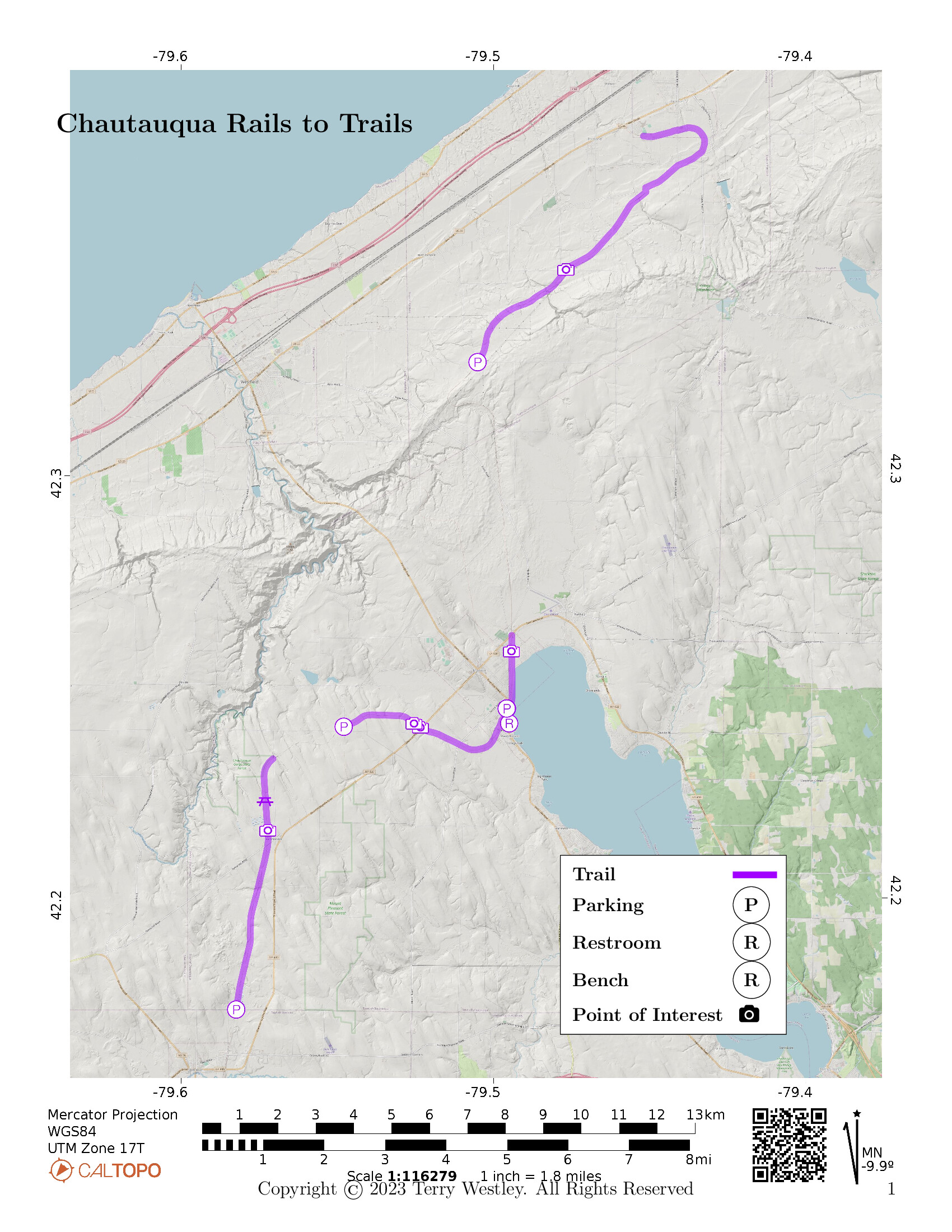
The map below shows the contiguous trail from Sherman, through Mayville to Brocton.
The trail is 24.4 miles point to point, very little of which is paved.
There are short paved stretches in Mayville and Brocton.
The rest is ballast, gravel, dirt, and grass.
The trail has its own Facebook page
is a not for profit entity that works to convert abandoned railbeds in Chautauqua County, NY, into trails.
The map below shows the contiguous trail from Sherman, through Mayville to Brocton.
The trail is 24.4 miles point to point, very little of which is paved.
There are short paved stretches in Mayville and Brocton.
The rest is ballast, gravel, dirt, and grass.
The trail has its own Facebook page![]() .
.
To make the trail more user friendly, CR2T has divided it into these segments:
| Trail name and link | Distance | Elevation Gain | Trail Surface |
|---|---|---|---|
| Alison Wells Ney Trail | 7.3 miles | 697 feet | Ballast, gravel, grass, asphalt |
| Carroll Area Nature Trail | 2.0 miles | ||
| James “Jim” Fincher Trail | 1.0 miles | 49 feet | Gravel |
| Laurie A. Baer Trail | 1.0 miles | 56 feet | Grass, gravel, and ballast |
| Mayville Village Trail | 1.2 miles | 26 feet | Asphalt |
| Nadine and Paul Webb Trail | 1.9 miles | 138 feet | Asphalt, gravel, grass, dirt |
| Nancy B. Diggs Trail | 1.4 miles | 92 feet | Earth and grass with a little bit of gravel |
| Park to Titus Roadwalk Trail | 0.9 miles | 88 feet | |
| Ralph C. Sheldon Jr. Trail | 4.2 miles | 266 feet | Gravel, grass, packed earth, stone, and dirt road |
| Rosie Billquist Trail | 0.9 miles | 50 feet | |
| Summerdale to Hannum Roadwalk Trail | 1.6 miles | 116 feet |
History
From A Railroad Slide Gallery![]() :
:
Mayville, New York is an attractive little town on Chautauqua Lake in upstate New York, just north of Chautauqua itself, famous for concerts and cultural events. The Pennsylvania Railroad’s Chautauqua Branch ran from Oil City, Pennsylvania through Corry, Clymer and Mayville and on to a junction with the Nickel Plate Road at Brockton. At Brockton the Pennsylvania used rails jointly owned with the Nickel Plate Road and served as a major route for coal heading to the steel mills at Lackawanna west of Buffalo. By this time the rails were coated with rust and the line was apparently out of service. This view from the New York Highway 394 bridge looks east; the Mayville station is visible just before the line curves to the left (north) to follow the lake shore.
Today the bridge and tracks are gone, but the station remains as the Mayville Depot Museum.
This stretch of track has a long and complex history. In 1864 the Cross Cut Railroad was incorporated to build north from Corry to the New York state line (roughly where Clymer is located) and the Buffalo & Oil Creek Cross Cut Railroad was formed to build from Brocton (where it connected with a precursor of the Lake Shore & Michigan Southern) south to the state line; both roads were built under the wing of the pre-Vanderbilt New York Central. In 1867 the two roads were consolidated as the Buffalo, Corry & Pittsburg, only to be renamed again in 1879 to the Buffalo, Chautauqua Lake & Pittsburg Railway. In 1880 it was merged into the Pittsburg, Titusville & Buffalo. At about this time it decided to build its own line to Buffalo, and since the Nickel Plate Road was also building along the lake shore (paralling the New York Central) the two roads shared a double-track line from Brocton to Buffalo. In 1889 it became part of the Western New York & Pennsylvania, after which their were no further changes of ownership until finally taken over by the Pennsylvania in 1900. For the entire convoluted story readers are encouraged to find a copy of The History of the Western New York & Pennsylvania and its predecessors and successors by Paul V. Pietrak, Joseph G. Streamer and James A. van Brocklin (Hamburg, N.Y., 2000).
Avenza Map
Avenza Map
- Load the PDF map into Avenza app on your smartphone in one of these ways:
- From your smartphone’s browser, tap this link to load the map directly into Avenza.
- From Avenza app’s Import Maps function, scan this QR code.

- Be sure to do this when you have good internet connection. Don’t wait until you are at the trailhead!
For more information about trail maps, see the Maps page.